Punchbowl Mosque, Sydney
Fakten und Informationen
Die Punchbowl-Moschee ist eine Moschee im Vorort Punchbowl von Sydney im australischen Bundesstaat New South Wales, die vom griechisch-australischen Architekten Angelo Candalepas entworfen wurde.
Das Gebäude besteht aus einer großen zentralen Kuppel und 102 kleineren Betonkuppeln, die mit islamischen Kalligraphien verziert sind, die die 99 Namen Allahs darstellen. Die Verwendung von Sichtbeton in der Moschee wurde mit dem Brutalismus verglichen, obwohl sich einige gegen diese Unterscheidung gewehrt haben.
Das Projekt begann ursprünglich 1996, als die muslimische Gemeinde drei benachbarte Grundstücke erwarb, um einen gemieteten Raum zu ersetzen. Die Genehmigung für das Projekt dauerte insgesamt 17 Jahre; das Verfahren wurde durch die Einwände der örtlichen Behörden erheblich verzögert. Der Bau des Gebäudes verzögerte sich weiter, weil ein Grundwasserspiegel entdeckt wurde, der Stadtrat von Canterbury weiterhin Einwände erhob und es schwierig war, Visa für die Kalligraphen zu erhalten, die das Gebäude verzieren sollten.
Das Gebäude erhielt die Sir John Sulman Medal 2018.
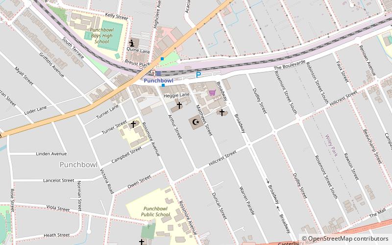
25-33 Matthews StreetCanterbury (Punchbowl)Sydney
- Busse
- Bahn
 Busse
Busse
- Bestimmen Sie die RoutePunchbowl 4 Min. Fußweg
- Bestimmen Sie die RouteWiley Park 17 Min. Fußweg
- Bestimmen Sie die RouteLakemba 30 Min. Fußweg
- Bestimmen Sie die RouteMarcella Street 28 Min. Fußweg
- Bestimmen Sie die RouteStacey Street South 29 Min. Fußweg
- Bestimmen Sie die RouteStand 2, Bankstown Central Shops 36 Min. Fußweg
- Bestimmen Sie die RouteStand 3, Bankstown Central Shops 36 Min. Fußweg
 Sydney-ZügeKarten
 Stadtbahn SydneyKarten
 Fähren


Häufig gestellte Fragen (FAQ)
Wie kommt man mit öffentlichen Verkehrsmitteln dorthin?
Bahn
- Punchbowl (4 Min. Fußweg)
- Wiley Park (17 Min. Fußweg)
Busse
- Marcella Street • Linien: M91 (28 Min. Fußweg)
- Stacey Street South • Linien: M91 (29 Min. Fußweg)