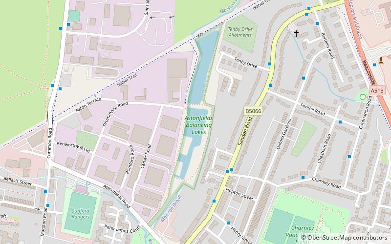
Astonfields Balancing Lakes, Stafford
Karte
Fakten und Informationen
Astonfields Balancing Lakes ist ein lokales Naturschutzgebiet am nordöstlichen Rand von Stafford in Staffordshire, England.
Der Hauptzweck der Ausgleichsseen ist der Hochwasserschutz; das Gebiet wurde auch als Lebensraum für Wildtiere entwickelt. Die Fläche beträgt etwa 4 Hektar und ist als biologisch bedeutsames Gebiet der Stufe 1 ausgewiesen.
Höhe: 269 ft ü. d. M.Koordinaten: 52°49'16"N, 2°6'42"W
Adresse
Astonfields Industrial Estate, Drummond RdStafford
KontaktHinzufügen
Soziale Medien
Hinzufügen
Zugang mit öffentlichen Verkehrsmitteln
Haltestellen der öffentlichen Verkehrsmittel in der Nähe des Standorts
- Busse
 Busse
Busse
- Bestimmen Sie die RouteGaol Square Bus Station 22 Min. Fußweg
- Bestimmen Sie die RouteGaol Square 22 Min. Fußweg
- Bestimmen Sie die RouteGatehouse Theatre 25 Min. Fußweg
- Bestimmen Sie die RouteShrewsbury Arms PH 26 Min. Fußweg
Tagesausflüge


Häufig gestellte Fragen (FAQ)
Wie kommt man mit öffentlichen Verkehrsmitteln dorthin?
Bahnhöfe und Haltestellen in der Umgebung von Astonfields Balancing Lakes:
Busse
Busse
- Gaol Square Bus Station (22 Min. Fußweg)
- Gaol Square • Linien: 877, 878 (22 Min. Fußweg)