United Nations Plaza, San Francisco


Faits et informations pratiques
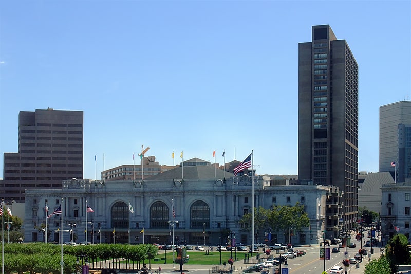
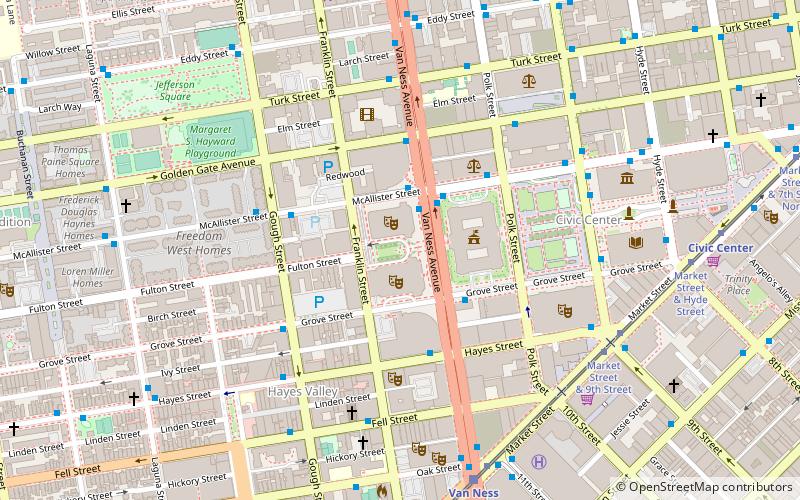
La Plaza des Nations Unies, située au cœur de San Francisco, est un espace urbain symbolique qui reflète l'engagement de la ville envers les principes de paix et d'unité internationales incarnés par l'organisation mondiale du même nom. Cette place, souvent désignée par son nom anglais "United Nations Plaza", se trouve à l'intersection de Market Street et Hyde Street, et s'étend le long de Fulton Street, offrant un espace ouvert aux résidents comme aux visiteurs.
Inaugurée en 1975, la plaza a été conçue par l'architecte Lawrence Halprin, connu pour ses travaux sur des espaces publics intégrant l'eau et le paysage. Ce site a été choisi pour honorer la signature de la Charte des Nations Unies en 1945, événement historique qui s'est déroulé au War Memorial Opera House de San Francisco, non loin de là. La Plaza est donc empreinte d'une signification historique, rappelant le rôle clé de la ville dans la création de l'ONU.
L'aménagement de la United Nations Plaza comprend une série de fontaines et de jets d'eau, ainsi que des bancs et des espaces verts, invitant à la détente et à la contemplation. Des pavés gravés avec les noms des États membres de l'ONU jalonnent le sol, créant un lien tangible avec les nations du monde entier.
La plaza est également connue pour accueillir des événements culturels et des marchés hebdomadaires, tels que le célèbre Heart of the City Farmers' Market, un marché de producteurs locaux qui se tient deux fois par semaine. Ce marché est une source importante de produits frais pour les habitants et les travailleurs du centre-ville de San Francisco.
De plus, la Plaza des Nations Unies sert de point de convergence pour de nombreuses manifestations civiques et manifestations, témoignant de l'esprit engagé et souvent avant-gardiste de la population de San Francisco. Elle est un lieu de rassemblement pour la communauté, où se déroulent des débats publics et des expressions de solidarité internationale.
1 United Nations PlzNortheast San Francisco (Civic Center)San Francisco
- Métro
- Autobus
- Trolleybus
- Trams
- Métro léger
- Chemin de fer
- Ferry
 Métro
Métro
- Déterminer l'itinéraireCivic Center 1 min. de marche
- Déterminer l'itinérairePowell Street 13 min. de marche
- Déterminer l'itinéraireCivic Center 1 min. de marche
- Déterminer l'itinéraireVan Ness 12 min. de marche
- Déterminer l'itinérairePowell Street 12 min. de marche
- Déterminer l'itinéraireMontgomery Street 24 min. de marche
- Déterminer l'itinéraireMarket Street & Leavenworth Street 2 min. de marche
- Déterminer l'itinéraireMcAllister Street & Leavenworth Street 2 min. de marche
- Déterminer l'itinéraireMarket Street & Hyde Street 2 min. de marche
- Déterminer l'itinéraireHyde Street & Grove Street 3 min. de marche
- Déterminer l'itinéraireMarket Street & 7th Street 2 min. de marche
- Déterminer l'itinéraireMission Street & 7th Street 5 min. de marche
- Déterminer l'itinéraireSan Francisco 4th & King Street 28 min. de marche
- Déterminer l'itinéraireFerry Building Gate B 42 min. de marche
 Muni Metro
United Nations Plaza – populaire dans la région (distance de cette attraction)
À proximité, vous trouverez notamment des attractions telles que : Bill Graham Civic Auditorium, Hôtel de ville de San Francisco, Musée d'Art asiatique de San Francisco, Pioneer Monument.


Foire aux questions (FAQ)
Quelles sont les attractions populaires à proximité ?
Comment s'y rendre par les transports publics ?
Métro
- Civic Center • Lignes: Blue, Green, Red, Yellow (1 min. de marche)
- Powell Street • Lignes: Blue, Green, Red, Yellow (13 min. de marche)
Métro léger
- Civic Center • Lignes: K, N, S, T (1 min. de marche)
- Van Ness • Lignes: K, N, S, T (12 min. de marche)
Autobus
- Market Street & Leavenworth Street • Lignes: 7, 800 (2 min. de marche)
- McAllister Street & Leavenworth Street • Lignes: 5 (2 min. de marche)
Trams
- Market Street & 7th Street • Lignes: F (2 min. de marche)
Trolleybus
- Mission Street & 7th Street • Lignes: 14 (5 min. de marche)
Chemin de fer
- San Francisco 4th & King Street (28 min. de marche)
Ferry
- Ferry Building Gate B • Lignes: San Francisco Bay Ferry (42 min. de marche)