East Park, Wolverhampton
Faits et informations pratiques
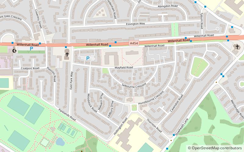
East Park est un parc à Wolverhampton, en Angleterre. La population de Wolverhampton Ward réalisée lors du recensement de 2011 était de 12 497. Situé au large de l'avenue Hickman, près de Monmore Green Stadium, le parc a de bonnes liaisons de transport vers le centre-ville.
Son nom est également utilisé pour le quartier d'East Park, qui couvre les régions de Monmore Green et Deansfield.
Les travaux ont commencé sur le design original "Utile Dolci" de Thomas Mawson sur 18 hectares de terrain donnés par le duc de Sutherland, Sir Alfred Hickman et M. Arther Sparrow en 1892, avec l'ouverture du parc pour les affaires le 21 septembre 1896.
Le design original comprenait un lac de navigation de plaisance; Cependant, cela était assailli de problèmes que de vieilles mines de charbon qui étaient auparavant là-bas ont commencé à drainer l'eau du lac. Malgré de grands efforts pour sauver le lac, il a été gazonné en 1922 et fait maintenant partie d'un terrain de jeu pour enfants et d'un terrain de sport. Cela a depuis été transformé en parking en 2013.
Le parc comprend la tour de l'horloge commémorative Lysaght, mais cela est en panne depuis plus de 30 ans, bien que les rumeurs continuent de circuler selon lesquelles le financement sera disponible pour rénover cela dans un avenir proche, et un petit stand à l'origine à l'origine financé par le produit d'une fête florale. Bien que actuellement réparable selon la base de données Scottish Ironwork Le bandeau est actuellement considéré comme "à la" Risque "ayant subi des années de négligence et de vandalisme. Les retraités se réunissent souvent au Memorial Clock Tower pour Sandwich Club.
Les installations actuelles comprennent des terrains de football, des courts de tennis, des terrains de jeux pour enfants, du Speedway, du cycle, du fitness et de l'équipement d'exercice aux côtés des jardins, des passerelles et des parterres de fleurs.
Une fois par an, le festival Wolvestock4Life a lieu. Il est hébergé par East Park depuis plus de dix ans et apporte chaque année plus de 4 000 personnes. Le festival, maintenant dans sa 14e année, est le plus grand festival gratuit au Royaume-Uni. Il n'est plus gratuit depuis 2013.
Une subvention de loterie de 981 000 £ a été accordée en décembre 2011 pour stabiliser les mines de charbon susmentionnées et rénover les installations du parc, y compris la tour de l'horloge.
East ParkWolverhampton
- Autobus
- Trams
- Chemin de fer
 Autobus
- Déterminer l'itinéraireWillenhall Rd / Mayfield Medical Centre 3 min. de marche
- Déterminer l'itinéraireWillenhall Rd / East Park Way 6 min. de marche
- Déterminer l'itinéraireStowheath Lane / Thornton Rd 7 min. de marche
- Déterminer l'itinérairePriestfield 19 min. de marche
- Déterminer l'itinéraireThe Royal 25 min. de marche
- Déterminer l'itinéraireThe Crescent 29 min. de marche
- Déterminer l'itinéraireBilston Central 36 min. de marche
- Déterminer l'itinéraireWolverhampton 30 min. de marche


Foire aux questions (FAQ)
Quelles sont les attractions populaires à proximité ?
Comment s'y rendre par les transports publics ?
Autobus
- Willenhall Rd / Mayfield Medical Centre • Lignes: 529, 53 (3 min. de marche)
- Willenhall Rd / East Park Way • Lignes: 529, 53, X529 (6 min. de marche)
Trams
- Priestfield • Lignes: 1 (19 min. de marche)
- The Royal • Lignes: 1 (25 min. de marche)
Chemin de fer
- Wolverhampton (30 min. de marche)