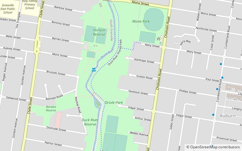
Oriole Park, Sydney
Map
Facts and practical information
Oriole Park was the home of the Auburn Baseball Club in New South Wales, Australia. It hosted the Claxton Shield in 1970, 1975, 1980, and 1981. The field was extended and had lighting added prior to hosting the 1980 competition. Oriole Park also held the 1988 U-18 Baseball World Cup. ()
Opened: 1960 (66 years ago)Coordinates: 33°51'8"S, 151°1'5"E
Address
AuburnSydney
ContactAdd
Social media
Add
Getting there by public transportation
Public transportation stops near this location
- Bus
- Train
 Bus
Bus
- Calculate routeAubrey Street 15 min walk
- Calculate routeGranville East Primary School 15 min walk
- Calculate routeDellwood Shops 15 min walk
- Calculate routeRedfern Street, Granville 17 min walk
- Calculate routeAuburn 23 min walk
- Calculate routeClyde 29 min walk
Maps Sydney TrainsMaps
 Sydney Light RailMaps
 Sydney Ferries
Sydney TrainsMapsSydney Light RailMapsSydney FerriesDay trips


Frequently Asked Questions (FAQ)
How to get to Oriole Park by public transport?
The nearest stations to Oriole Park:
Bus
Train
Bus
- Aubrey Street • Lines: M91 (15 min walk)
- Granville East Primary School • Lines: M91 (15 min walk)
Train
- Auburn (23 min walk)
- Clyde (29 min walk)