Churn Creek Protected Area


Facts and practical information
The Churn Creek Protected Area is a 36,747-hectare provincial protected area in British Columbia, Canada. It is a mix of dryland canyon and steppe and adjoining rangeland flanking the canyon of Churn Creek and that stream's confluence with the Fraser River at the northern apex of the Camelsfoot Range. The historic Gang Ranch is just north of the Churn Creek Protected Area. The Empire Valley Ranch ecological preserve was added to the Protected Area in an expansion. ()
Best Ways to Experience the Park
Wildlife
AnimalsSee what popular animal species you can meet in this location.
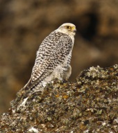
Gyrfalcon
The gyrfalcon, the largest of all falcon species, is a magnificent bird of prey that inhabits the Arctic regions and the northern islands of North America as well as the Eurosiberian region. One of its notable traits is sexual dimorphism, where females are larger than...
Birds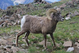
Bighorn, Mountain Sheep
The bighorn sheep (Ovis canadensis), a majestic species native to North America, derives its name from its impressive, large horns. Recent genetic testing has identified three subspecies, one of which is currently endangered.
Mammals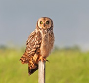
Short-eared owl
The short-eared owl is a captivating bird belonging to the genus Asio. It earns its name from the tufts of feathers on its head that resemble ears, although these "ears" are not always visible unless the owl adopts a defensive posture.
Birds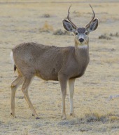
Mule deer
The mule deer is a captivating species native to western North America, easily identifiable by its large, mule-like ears. Unlike the white-tailed deer, mule deer predominantly inhabit the western Great Plains, Rocky Mountains, southwestern United States, and the West...
Mammals
Prairie falcon
The prairie falcon is a medium-large bird of prey native to the western regions of North America. Comparable in size to the peregrine falcon, females tend to be slightly larger than males. Adapted to harsh desert environments, the prairie falcon is a formidable hunter...
Birds