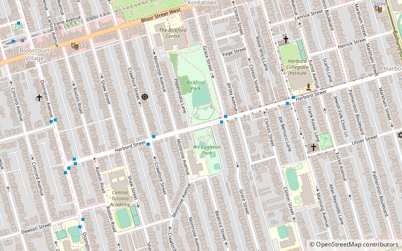
Harbord Street Bridge, Toronto
Map
Facts and practical information
Harbord Street Bridge is one of two known bridges that once spanned Harbord Street over Garrison Creek in Toronto and was partially buried intact in the 20th Century. ()
Coordinates: 43°39'35"N, 79°25'7"W
Address
West End (Bickford Park)Toronto
ContactAdd
Social media
Add
Getting there by public transportation
Public transportation stops near this location
- Metro
- Bus
- Tram
 Metro
Metro
- Calculate routeGrace Street 2 min walk
- Calculate routeCrawford Street 3 min walk
- Calculate routeManning Avenue 6 min walk
- Calculate routeChristie 8 min walk
- Calculate routeOssington 12 min walk
- Calculate routeBathurst 14 min walk
- Calculate routeDufferin 22 min walk
- Calculate routeCrawford Street 8 min walk
- Calculate routeGrace Street 10 min walk
- Calculate routeOssington Avenue 12 min walk
Maps SubwayMaps
 Streetcar systemMaps
 PATH
PATH
SubwayMapsStreetcar systemMapsPATHDay trips


Frequently Asked Questions (FAQ)
Which popular attractions are close to Harbord Street Bridge?
Nearby attractions include Palmerston-Little Italy, Toronto (4 min walk), Church of St. Mary Magdalene, Toronto (7 min walk), Christie Pits Park, Toronto (10 min walk), Little Italy, Toronto (10 min walk).
How to get to Harbord Street Bridge by public transport?
The nearest stations to Harbord Street Bridge:
Bus
Metro
Tram
Bus
- Grace Street • Lines: 94A (2 min walk)
- Crawford Street • Lines: 94A (3 min walk)
Metro
- Christie • Lines: 2 (8 min walk)
- Ossington • Lines: 2 (12 min walk)
Tram
- Crawford Street • Lines: 306, 506 (8 min walk)
- Grace Street • Lines: 306, 506 (10 min walk)