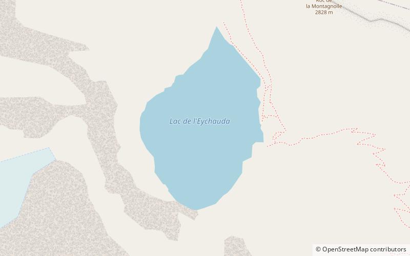
Lac de l'Eychauda, Écrins National Park
#8 among attractions in Écrins National Park


Facts and practical information
Lac de l'Eychauda is a lake in Hautes-Alpes, France. ()
Écrins National Park France
Écrins National Park plan & book
Unleash the traveler in you — discover the cheapest flight deals, find the perfect hotel or hostel nearby, and search for the best car rental prices. Travel at your own pace to discover new places and enjoy your journey.
Lac de l'Eychauda – popular in the area (distance from the attraction)
Nearby attractions include: Les Grands Bains, Pic de Neige Cordier, La Baignade Bio de Chantemerle, Glacier Blanc.
3.3 miNE44°58'28"N • 6°30'21"ELes Grands Bains, Le Monêtier-les-Bains
83 min walk • Watersports, Thermal spa, Outdoor activities
4.6 miWNature, Natural attraction, MountainPic de Neige Cordier, Écrins National Park
119 min walk • Pic de Neige Cordier is a mountain in the Massif des Écrins range, located in the Hautes-Alpes département of France. The mountain is named after the French alpinist Henri Cordier.
5.2 miE44°56'7"N • 6°34'60"ELa Baignade Bio de Chantemerle, Serre-Chevalier
132 min walk • Watersports, Swimming pool, Swimming
4.9 miWNature, Natural attraction, Natural featureGlacier Blanc, Écrins National Park
126 min walk • The Glacier Blanc is a glacier in the French département of Hautes-Alpes. Its name derives from the fact that – unlike the nearby Glacier Noir – its surface appears pristinely white due to an absence of morainic debris.
2.7 miNWNature, Natural attraction, MountainLes Agneaux, Écrins National Park
68 min walk • Les Agneaux is a mountain of the Massif des Écrins in Hautes-Alpes, France. Standing at 3,664 m in elevation, It is located in the commune of Pelvoux.
5.2 miWNature, Natural attraction, Natural featureGlacier Noir, Écrins National Park
132 min walk • The Glacier Noir is a glacier in the Massif des Écrins in the French Alps. It is located in the département of Hautes-Alpes.
5.7 miNEForts and castlesOuvrage Col de la Buffère
146 min walk • Ouvrage Col de Buffere is a lesser work of the Maginot Line's Alpine extension, the Alpine Line. The ouvrage consists of one combat block at an altitude of 2,393 metres on the Col de la Buffère. Additional blocks were planned but not built or were left incomplete.
5.9 miSWHiking, Alpine hutRefuge du Sélé, Écrins National Park
150 min walk • Refuge du Sélé is a refuge in the Alps.
5.3 miSWNature, Natural attraction, MountainPic Sans Nom, Écrins National Park
136 min walk • The Pic Sans Nom is a mountain in the Massif des Écrins in the French Alps. It lies in the middle of the steep mountain mass that runs south-west from Mont Pelvoux to the Ailefroide.
4.7 miSWNature, Natural attraction, MountainMont Pelvoux, Écrins National Park
121 min walk • Mont Pelvoux is a mountain in the Massif des Écrins in the French Alps. It stands 3,946 m in elevation. For many years, Mont Pelvoux was believed to be the tallest mountain in the region, since the taller Barre des Écrins cannot be seen from the Durance valley.
4.8 miWHiking, Alpine hut, Vernacular architectureRefuge des Écrins, Écrins National Park
122 min walk • Refuge des Écrins is a refuge in the Alps, in the French department of Hautes-Alpes. It stands at 3170 metres high, above the Glacier Blanc. Access usually is from the village of Ailefroide in the French Alps and a 2-hour hike further than the Refuge du Glacier Blanc.