Longchamp Abbey, Paris
Map
Facts and practical information
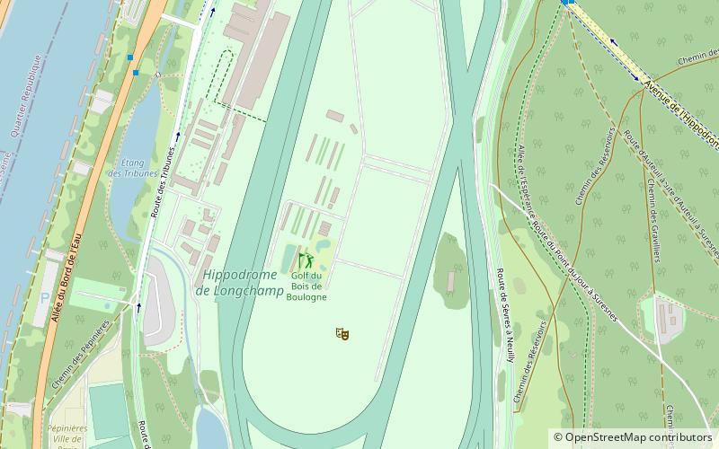
Longchamp Abbey, known also as the Convent of the Humility of the Blessed Virgin, was a convent of Poor Clares founded in 1255 in Auteuil, Paris, by Saint Isabelle of France. The site is now occupied by Longchamp Racecourse. ()
Address
Passy (Auteuil)Paris
ContactAdd
Social media
Add
Getting there by public transportation
Public transportation stops near this location
- Metro
- Bus
- Tram
- Train
 Metro
Metro
- Calculate routeHippodrome de Longchamp 8 min walk
- Calculate routeAllée de l'Espérance 9 min walk
- Calculate routeRue du Val d'Or 12 min walk
- Calculate routeClavel 12 min walk
- Calculate routeLes Coteaux 16 min walk
- Calculate routeLes Milons 21 min walk
- Calculate routeSuresnes - Longchamp 23 min walk
- Calculate routeParc de Saint-Cloud 31 min walk
- Calculate routeLe Val d'Or 21 min walk
- Calculate routeSuresnes Mont-Valérien 28 min walk
- Calculate routeSaint-Cloud 29 min walk
- Calculate routeBoulogne - Jean Jaurès 30 min walk
- Calculate routePorte d'Auteuil 34 min walk
Maps Metro
Metro
MetroDay trips


Frequently Asked Questions (FAQ)
Which popular attractions are close to Longchamp Abbey?
Nearby attractions include Château Rothschild, Boulogne-Billancourt (15 min walk), Bois de Boulogne, Paris (22 min walk), Bagatelle Gamefield, Paris (23 min walk).
How to get to Longchamp Abbey by public transport?
The nearest stations to Longchamp Abbey:
Bus
Tram
Train
Metro
Bus
- Hippodrome de Longchamp • Lines: 241, 43 (8 min walk)
- Allée de l'Espérance • Lines: 70 (9 min walk)
Tram
- Les Coteaux • Lines: T2 (16 min walk)
- Les Milons • Lines: T2 (21 min walk)
Train
- Le Val d'Or (21 min walk)
- Suresnes Mont-Valérien (28 min walk)
Metro
- Boulogne - Jean Jaurès • Lines: 10 (30 min walk)
- Porte d'Auteuil • Lines: 10 (34 min walk)