
Sipacate-Naranjo National Park Travel Guide
Facts and practical information
Located in the Escuintla region of Guatemala, Sipacate-Naranjo National Park is a true gem for nature enthusiasts and adventure seekers. The park is known for its stunning coastline, pristine beaches, and diverse wildlife, making it a must-visit destination for those looking to experience the natural beauty of Guatemala.
One of the highlights of Sipacate-Naranjo National Park is its beautiful beaches, which are perfect for sunbathing, swimming, and beachcombing. The park's coastline offers breathtaking views of the Pacific Ocean, and visitors can enjoy long walks along the sandy shores or relax under the shade of palm trees.
In addition to its beaches, Sipacate-Naranjo National Park is also home to a rich variety of flora and fauna. The park's diverse ecosystem includes mangrove forests, wetlands, and coastal dunes, providing a habitat for numerous species of birds, reptiles, and marine life. Birdwatchers will delight in the opportunity to spot colorful tropical birds, while nature lovers can explore the park's trails and discover its unique plant life.
For those seeking adventure, Sipacate-Naranjo National Park offers plenty of opportunities for outdoor activities. Visitors can go kayaking in the park's mangrove forests, take a boat tour to observe the local wildlife, or try their hand at fishing in the Pacific Ocean. The park is also popular for surfing, with its strong waves attracting surfers from around the world.
Escuintla
Sipacate-Naranjo National Park Attractions - What to See and Explore
Sipacate-Naranjo National Park offers many attractions and places to visit. Here are the most important ones: Sipacate. Below you will find a complete list of places worth visiting.
Best Time To Visit Sipacate-Naranjo National Park
Learn when is the best time to travel to Sipacate-Naranjo National Park weather-wise and what to expect in each season.
Best Ways to Experience the Park
Wildlife
AnimalsSee what popular animal species you can meet in this location.

Hawksbill Turtle
The hawksbill sea turtle, a critically endangered species in the Cheloniidae family, is the only extant member of the Eretmochelys genus. These turtles are distributed globally, with populations in both the Atlantic and Indo-Pacific regions.
Reptiles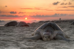
Olive Ridley
The olive ridley sea turtle, scientifically known as *Lepidochelys olivacea*, is a fascinating member of the Cheloniidae family. It is the second smallest and most abundant sea turtle species, thriving in the warm, tropical waters of the Pacific, Indian, and Atlantic...
Reptiles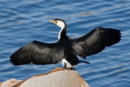
Cormorant
Cormorants and shags, members of the Phalacrocoracidae family, are captivating aquatic birds encompassing about 40 different species. These birds, ranging from medium to large in size, are easily recognized by their dark plumage, long hooked bills, and webbed feet...
Birds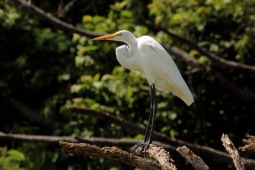
Great egret
The great egret, also known as the common egret, large egret, great white egret, or great white heron, is a remarkable bird found across Asia, Africa, the Americas, and southern Europe. As a member of the heron family, Ardeidae, and classified under the genus Ardea...
Birds
Least tern
The least tern is a petite and captivating bird found throughout North and South America. It is closely related to the little tern from the Old World, along with species like the yellow-billed tern and the Peruvian tern.
Birds