Dong Hua Sao National Protected Area


Facts and practical information
Dong Hua Sao National Protected Area is a national protected area in Champasak Province in southern Laos. This forested park rises from the Mekong river lowlands eastwards into the Bolaven Plateau. It is an ecotourism destination. ()
Champasak
Best Ways to Experience the Park
Wildlife
AnimalsSee what popular animal species you can meet in this location.
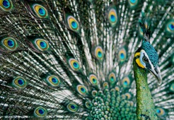
Green peafowl
The green peafowl, native to Southeast Asia, is an endangered species primarily due to habitat loss and fragmentation. Unlike the more familiar Indian peafowl, male and female green peafowls appear quite similar, both exhibiting large bodies with iridescent green...
Birds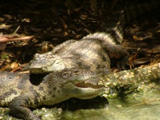
Siamese crocodile
The Siamese crocodile, also known as the Siamese freshwater crocodile, is a critically endangered species native to several Southeast Asian countries. This medium-sized crocodile is characterized by its olive-green color and varies in size depending on age and gender.
Reptiles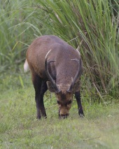
Indian hog deer
Hyelaphus is a genus of small deer native to South and Southeast Asia. These deer, distinguished by their brown coats, are currently facing the threat of extinction. There are three species within this genus, with two being endemic to small islands, underscoring the...
Mammals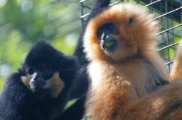
Yellow-cheeked gibbon
The yellow-cheeked gibbon, also known by various other names, is a captivating primate species native to Vietnam, Laos, and Cambodia. Named after the British naturalist Gabrielle Maud Vassal, these gibbons are born with blond fur that turns black as they mature, with...
Mammals