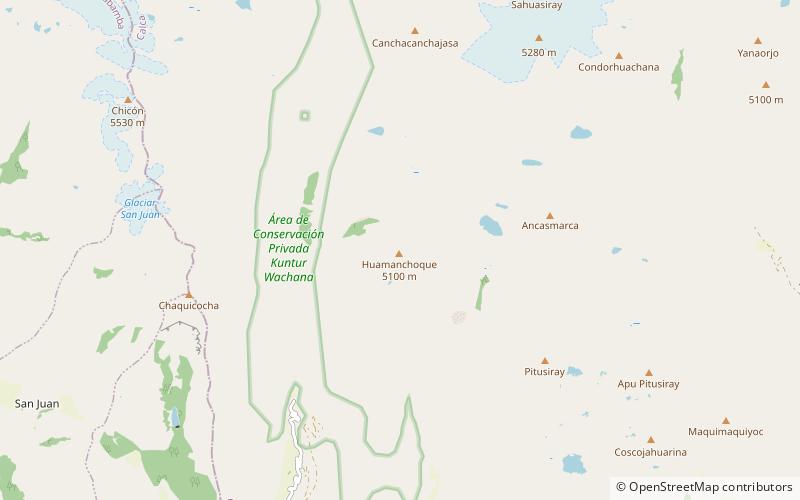
Huamanchoque
#510 among destinations in Peru

Facts and practical information
Huamanchoque (possibly from Quechua waman falcon or variable hawk, chuqi metal, every kind of precious metal / gold ( ()
CuscoPeru
Huamanchoque plan & book
Unleash the traveler in you — discover the cheapest flight deals, find the perfect hotel or hostel nearby, and search for the best car rental prices. Travel at your own pace to discover new places and enjoy your journey.
Huamanchoque – popular in the area (distance from the attraction)
Nearby attractions include: Sahuasiray, Sirihuani, Museum Inkariy, Chicón.
 Nature, Natural attraction, Mountain
Sahuasiray
86 min walk • Sahuasiray, Sawasiray, Colque Cruz or Ccolque Cruz, is one of the highest mountains in the Urubamba mountain range in the Andes of Peru, about 5,818 metres high. It lies in the Cusco Region, Calca Province, northwest of Calca.
 Nature, Natural attraction, Mountain
Sirihuani
118 min walk • Sirihuani or Sirijuani is a 5,359-metre-high mountain in the Urubamba mountain range in the Andes of Peru. It is located in the Cusco Region, Calca Province, in the districts of Calca and Lares.
 13°19'4"S • 71°59'35"W
Museum Inkariy, Urubamba
112 min walk • Specialty museum, History museum, Museum
 Nature, Natural attraction, Mountain
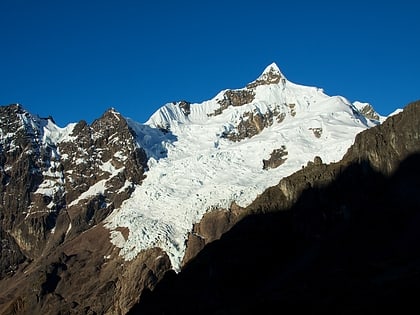
Chicón
84 min walk • Chicón or Chicon is a mountain in the Urubamba mountain range in the Andes of Peru, about 5,530 m high. It is located in the Cusco Region, Calca Province, Calca District and in the Urubamba Province, Urubamba District. It is situated northeast of the town of Yucay, southeast of Pumahuanca and southwest of the Sirihuani.
 Nature, Natural attraction, Mountain
Ancasmarca
47 min walk • Ancasmarca, also known as Pitusiray or Sallcasa, is a 5,198-metre-high mountain in the Urubamba mountain range in the Andes of Peru. It is located in the Cusco Region, Calca Province, Calca District, north of the Vilcanota River.
 Archaeological site
Quispiguanca
163 min walk • Quispiguanca, also Q'espihuanca and Q'espiwanka, was a royal estate of the Inca emperor Huayna Capac. The ruins of the estate are located in the northern part of the present-day town of Urubamba, Peru at an elevation of 2,910 metres.
 Nature, Natural attraction, Mountain
Pitusiray
54 min walk • Pitusiray is a 4,991-metre-high mountain in the Urubamba mountain range in the Andes of Peru. It is located in the Cusco Region, Calca Province, Calca District, north of the Vilcanota River.
 Nature, Natural attraction, Mountain
Canchacanchajasa
66 min walk • Canchacanchajasa is a 4,987-metre-high mountain in the Urubamba mountain range in the Andes of Peru. It is located in the Cusco Region, Calca Province, Calca District, north of the Urubamba River.
 Nature, Natural attraction, Mountain
Pucajasa
151 min walk • Pucajasa is a mountain in the Urubamba mountain range in the Andes of Peru, about 4,800 m high. It is located in the Cusco Region, Urubamba Province, Urubamba District. It lies at the pass named Pumahuancajasa.
 Locality
Yucay
169 min walk • Yucay is a town in southern Peru. It is the capital of the Yucay District, which is near the center of Urubamba Province. Urubamba Province is in the Cusco Region of southern Peru.
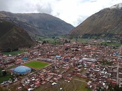 Town
TownCalca
147 min walk • One of the main attractions in Calca is the lively Sunday market, where locals from surrounding villages come to sell their produce, handicrafts, and textiles. Visitors can wander through the colorful stalls, sampling fresh fruits and vegetables, and picking up unique...


