Doi Khun Tan National Park

Facts and practical information
Doi Khun Tan National Park straddles the mountainous area of the Khun Tan Range in Lamphun and Lampang Provinces, northern Thailand. ()
Lampang
Best Ways to Experience the Park
Wildlife
AnimalsSee what popular animal species you can meet in this location.
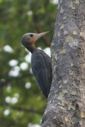
Great slaty woodpecker
The great slaty woodpecker, the largest extant woodpecker species, belongs to the Picidae family and is native to the Indian Subcontinent and Southeast Asia. This impressive bird favors primary semi-open forests, moist deciduous forests, and tropical evergreen forests.
Birds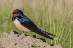
Barn swallow
The barn swallow is a bird that can be found all over the world, from Europe and Asia to Africa and the Americas. You can easily identify it by its striking blue upper feathers and deeply forked tail. Despite some declines in local populations, the barn swallow is not...
Birds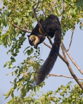
Black giant squirrel
The black giant squirrel, also known as the Malayan giant squirrel, is one of the most striking members of the squirrel family. Belonging to the genus Ratufa, this large tree squirrel inhabits a range of countries in the Indomalayan region, including Bangladesh, India...
Mammals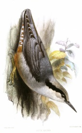
Giant nuthatch
The giant nuthatch, the largest bird in the Sittidae family, measures approximately 19.5 centimeters in length. Primarily grey, females display a subtle reddish tint on their underparts and have a more robust bill compared to other nuthatches.
Birds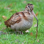
Eurasian woodcock
The Eurasian woodcock is a captivating medium-small wading bird native to the temperate and subarctic regions of Eurasia. Renowned for its exceptional camouflage, this bird features reddish-brown upperparts and buff-colored underparts, allowing it to blend effortlessly...
Birds