Meall Glas
#3325 among destinations in the United Kingdom
Facts and practical information
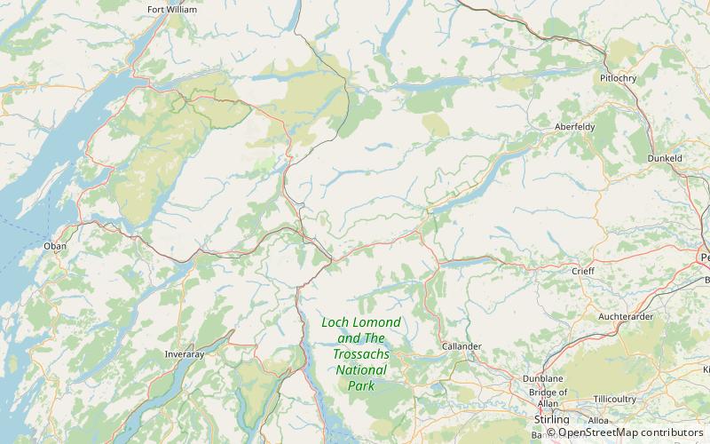
Meall Glas is a mountain situated in the southern highlands of Scotland. It stands on the northern border of the Loch Lomond and the Trossachs National Park, 8.5 kilometres north east of Crianlarich. ()
ScotlandUnited Kingdom
Meall Glas – popular in the area (distance from the attraction)
Nearby attractions include: Ben More, Beinn Challuim, Lochan Saorach, Beinn a' Chaisteil.
4.8 miSNatural attraction, MountainBen More, Crianlarich
124 min walk • Ben More is a mountain in the southern Highlands of Scotland, near Crianlarich. It is the highest of the so-called Crianlarich Hills to the south-east of the village, and there is no higher land in the British Isles south of Ben More.
2.8 miWNature, Natural attraction, MountainBeinn Challuim
71 min walk • Beinn Challuim is a Scottish mountain in the very northern part of the Loch Lomond and the Trossachs National Park six kilometres east northeast of the village of Tyndrum in the Stirling Council area.
3.3 miSEValleyLochan Saorach, Loch Lomond and The Trossachs National Park
85 min walk • Lochan Saorach or Lochan Dun Saoraich is a small lake situated in Glen Dochart, below Dun Saorach, Perthshire, Scottish Highlands, Scotland. The glen extends from Crianlarich eastwards to Killin with the River Dochart passing through it.
5.8 miNWNature, Natural attraction, MountainBeinn a' Chaisteil
149 min walk • Beinn a' Chaisteil is a mountain in the southern Highlands of Scotland, it is located 6.25 km north of Tyndrum on the border of Perth and Kinross and Argyll and Bute council areas.
4 miNNature, Natural attraction, MountainBeinn Heasgarnich
101 min walk • Beinn Heasgarnich is a Scottish mountain. It lies approximately 2 km to the south of Loch Lyon.
3.5 miNWNature, Natural attraction, MountainCreag Mhòr
90 min walk • Creag Mhòr is a Scottish mountain which stands in the ancient Forest of Mamlorn deer forest, it is located ten kilometres north east of Tyndrum on the border between the Perth and Kinross and Stirling council areas.
6.9 miNENature, Natural attraction, MountainMeall Ghaordaidh
177 min walk • Meall Ghaordaidh is a mountain in the Southern Highlands of Scotland, approximately 10 km north-west of Killin.
2 miENature, Natural attraction, MountainSgiath Chùil, Loch Lomond and The Trossachs National Park
51 min walk • Sgiath Chùil is a mountain situated in the southern highlands of Scotland. It stands within Loch Lomond and the Trossachs National Park, on its northern border. It is about 11 kilometres west of Killin.
5.2 miSWNature, Natural attraction, ValleyStrath Fillan, Loch Lomond and The Trossachs National Park
133 min walk • Strath Fillan is a strath in west Perthshire named after an 8th-century Irish hermit monk later canonised Saint Fillan. Located in the region was once Strath Fillan Priory, an early 14th century foundation, later destroyed by the Campbells in the name of Calvinism.
6.3 miNWNature, Natural attraction, MountainBeinn Mhanach
161 min walk • Beinn Mhanach is a mountain situated on the northern side of Loch Lyon and eight kilometres east of Bridge of Orchy, in the west highlands of Scotland.
5.1 miSENature, Natural attraction, ValleyGlen Dochart, Loch Lomond and The Trossachs National Park
130 min walk • Glen Dochart in Perthshire, Scottish Highlands is a glen which runs from Crianlarich eastwards to Killin, following the course of the River Dochart as it flows through Loch Dochart and Loch Iubhair. It is met by Glen Ogle at Lix Toll. Lochan Saorach lies within the glen and was once famous for its Floating island.