Altar Stones Pavillion, Markfield
#1 among attractions in Markfield
![Altar Stones Pavillion location map](https://tzmedia.b-cdn.net/media/images/static-maps/gb/52_6918_-1_2848.jpg)
Facts and practical information
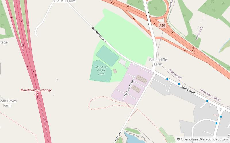
Altar Stones is a 3.7-hectare nature reserve in Markfield in Leicestershire. It is owned and managed by the Leicestershire and Rutland Wildlife Trust. ()
Altar Stones LaneMarkfield United Kingdom
Markfield plan & book
Unleash the traveler in you — discover the cheapest flight deals, find the perfect hotel or hostel nearby, and search for the best car rental prices. Travel at your own pace to discover new places and enjoy your journey.
Altar Stones Pavillion – popular in the area (distance from the attraction)
Nearby attractions include: Beacon Hill, Mount St Bernard Abbey, Old John, Charnwood Forest.
3 miNENature, Hill, ParkBeacon Hill, Loughborough
76 min walk • Beacon Hill, near Loughborough, in Leicestershire, England, is a popular country park. It is one of several beacon hills in the United Kingdom. It is part of Beacon Hill, Hangingstone and Outwoods Site of Special Scientific Interest.
3.8 miNWHistorical place, Church, MonasteryMount St Bernard Abbey, Coalville
96 min walk • Mount St Bernard Abbey is a Roman Catholic, Trappist monastery near Coalville, Leicestershire, England, founded in 1835 in the parish of Whitwick and now in that of Charley.
2.6 miETowerOld John
66 min walk • Old John is the highest hill in Bradgate Park, Leicestershire, England, on the southern edge of Charnwood Forest. It gives its name to the folly that stands at its top. The hill stands at 212 metres high, and is a prominent landmark across Leicester and Leicestershire.
1.6 miENature, Natural attraction, ForestCharnwood Forest
40 min walk • Charnwood Forest is an upland tract in north-western Leicestershire, England, bounded by Leicester, Loughborough and Coalville. The area is undulating, rocky and picturesque, with barren areas.
2.9 miEParkBradgate House, Bradgate Park
75 min walk • Bradgate House is a 16th-century ruin in Bradgate Park, Leicestershire, England. Edward Grey's son Sir John Grey of Groby married Elizabeth Woodville, who, after John's death married King Edward IV.
3.5 miEParkSwithland Wood and The Brand
91 min walk • Swithland Wood and The Brand is a 87.9 hectares biological Site of Special Scientific Interest south of Woodhouse Eaves in Leicestershire. Swithland Wood is a Nature Conservation Review site, Grade II.
3.2 miSEAreaGroby, Leicester
82 min walk • Groby is a large English village in the county of Leicestershire, to the north west of the city of Leicester. The population at the time of the 2011 census was 6,796.
2 miSParkThornton Reservoir
52 min walk • Thornton Reservoir is a small reservoir situated in the National Forest near the village of Thornton in Leicestershire. It has a surface area of 75 acres and a perimeter of 2.45 miles.
3.2 miNNature, Natural attraction, ForestFelicity's Wood
83 min walk • Felicity's Wood is a woodland in Leicestershire, England, near the village of Woodhouse Eaves. It covers a total area of 8.77 hectares. It is owned and managed by the Woodland Trust.
3.8 miENature, Natural attraction, LakeCropston Reservoir, Leicester
97 min walk • Cropston Reservoir lies in Charnwood Forest in Leicestershire, England. The dam and associated water works are in Cropston, while the bulk of the reservoir is in the neighbouring Newtown Linford parish.
1.1 miNEMuseum, History museumStoneywell
28 min walk • Stoneywell is a National Trust property in Ulverscroft, a dispersed settlement near Coalville in Charnwood Forest, Leicestershire. Stoneywell is the largest of a small group of cottages designed in the Arts and Crafts style by Ernest Gimson.