Convoys Wharf, London
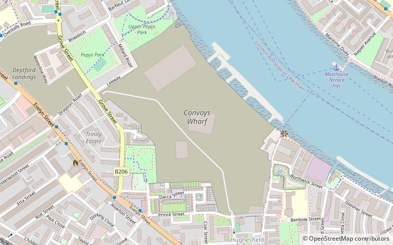
Map
Facts and practical information
Convoys Wharf, formerly called the King's Yard, is the site of Deptford Dockyard, the first of the Royal Dockyards, built on a riverside site in Deptford, by the River Thames in London, England. It was first developed in 1513 by Henry VIII to build vessels for the Royal Navy. Convoys Wharf also covers most of the site of Sayes Court manor house and gardens, home of diarist John Evelyn. ()
Getting there by public transportation
Public transportation stops near this location
- Metro
- Bus
- Light rail
- Train
- Ferry
 Metro
Metro
- Calculate routeMasthouse Terrace Pier 8 min walk
- Calculate routeGreenland Pier 16 min walk
- Calculate routeGreenwich Pier 22 min walk
- Calculate routeHarbinger School / Masthouse Terrace Pier 11 min walk
- Calculate routeSt Edmund's School 11 min walk
- Calculate routeMaconochies Road 12 min walk
- Calculate routeCrews Street / The Space Theatre 13 min walk
- Calculate routeDeptford 13 min walk
- Calculate routeNew Cross 18 min walk
- Calculate routeNew Cross Gate 23 min walk
- Calculate routeSurrey Quays 25 min walk
- Calculate routeMudchute Platform 1 18 min walk
- Calculate routeGreenwich Platform 4 20 min walk
- Calculate routeIsland Gardens Platform 2 20 min walk
- Calculate routeCanada Water 32 min walk
Maps Tube
Tube
TubeDay trips


Frequently Asked Questions (FAQ)
Which popular attractions are close to Convoys Wharf?
Nearby attractions include Deptford Wharf, London (11 min walk), The Space, London (12 min walk), Deptford Park, London (13 min walk), Folkestone Gardens, London (14 min walk).
How to get to Convoys Wharf by public transport?
The nearest stations to Convoys Wharf:
Ferry
Bus
Train
Light rail
Metro
Ferry
- Masthouse Terrace Pier • Lines: Rb1 (8 min walk)
- Greenland Pier • Lines: Rb1 (16 min walk)
Bus
- Harbinger School / Masthouse Terrace Pier • Lines: 277, N277 (11 min walk)
- St Edmund's School • Lines: 277, N277 (11 min walk)
Train
- Deptford (13 min walk)
- New Cross (18 min walk)
Light rail
- Mudchute Platform 1 • Lines: B-L, S-L (18 min walk)
- Greenwich Platform 4 • Lines: B-L, S-L (20 min walk)
Metro
- Canada Water • Lines: Jubilee (32 min walk)