Pigs Eye Lake, Saint Paul
Facts and practical information
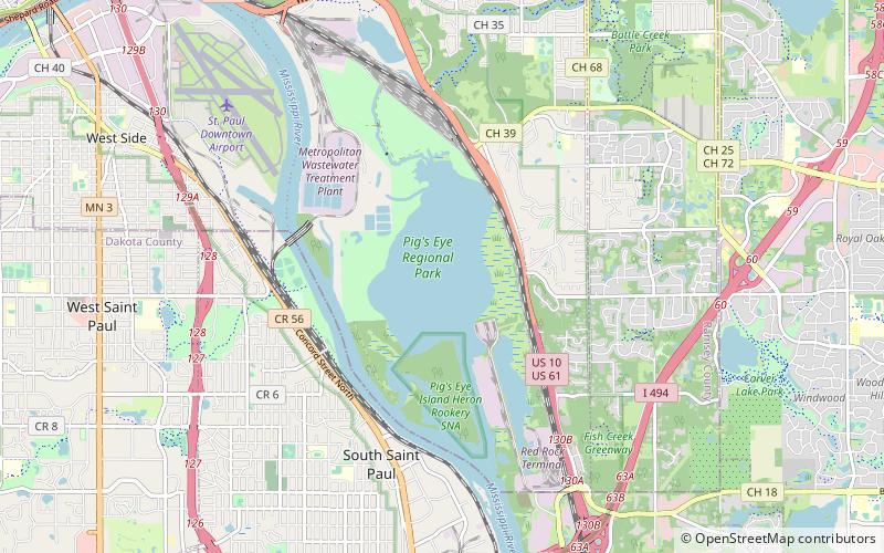
Pigs Eye Lake is a riverine wetland that covers 628 acres in Ramsey County, in the U.S. state of Minnesota. The Mdewakanton Village of Kaposia was located on the northern end until 1837 when the village was moved across the Mississippi to what is now South St. Paul. The 1930 construction of lock and dam #2 in Hastings down river, is responsible for its size and depth. The wetland is part of what the Army Corps of Engineers has designated as pond 2 of the upper Mississippi waterway. It is south of downtown St Paul on the east side of the river. Battle Creek enters the wetland from the northeast. In the 1960s the Army Corps of Engineers dredged two channels into it. One, out of the southwest corner, went due west out to the main river channel. The second went due south for barge traffic. Along that south channel the Army Corps created an industrial park with spoils from dredging the main channel. That portion of the industrial park has moorings for several barges at a time. In planning for the future the Army Corps built a levee defining the north side of the industrial park thereby creating an area for future dredging spoils. ()
HighwoodSaint Paul
- Bus
 Bus
Bus
- Calculate routeLower Afton Park & Ride 25 min walk
- Calculate routeLondin Lane & Winthrop Street 37 min walk


Frequently Asked Questions (FAQ)
How to get to Pigs Eye Lake by public transport?
Bus
- Lower Afton Park & Ride • Lines: 363 (25 min walk)
- Londin Lane & Winthrop Street • Lines: 323 (37 min walk)