Mount Olivet Cemetery, Salt Lake City
Map
Facts and practical information
Mount Olivet Cemetery is a cemetery in Salt Lake City, Utah. It was established on May 16, 1874, by an act of the U.S. Congress which granted 20 acres of land for public use as a cemetery. The first use of the cemetery was in 1877. The cemetery land originally consisted of exactly 20 acres and was part of the U.S. Army's Camp Douglas military reservation. Since that time, the allotment has been expanded and contracted; the present cemetery is approximately 80 acres. ()
Coordinates: 40°45'22"N, 111°50'60"W
Address
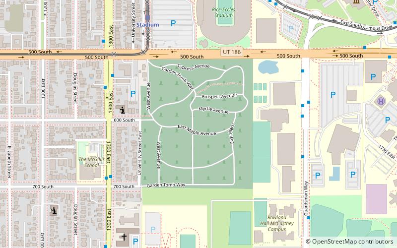
Garden Tomb WayEast Bench (University of Utah)Salt Lake City 84102
Contact
Social media
Add
Getting there by public transportation
Public transportation stops near this location
- Bus
- Light rail
 Bus
Bus
- Calculate routeStadium 7 min walk
- Calculate routeUniversity South Campus 16 min walk
- Calculate routeFort Douglas 23 min walk
- Calculate route900 East 24 min walk
- Calculate routeU President's Circle 15 min walk
- Calculate routeCentral Campus Drive @ 260 S 17 min walk
Day trips


Frequently Asked Questions (FAQ)
Which popular attractions are close to Mount Olivet Cemetery?
Nearby attractions include Salt Lake 2002 Olympic Cauldron Park, Salt Lake City (5 min walk), Carlson Hall, Salt Lake City (10 min walk), Utah Museum of Fine Arts, Salt Lake City (12 min walk), Pioneer Theatre Company, Salt Lake City (12 min walk).
How to get to Mount Olivet Cemetery by public transport?
The nearest stations to Mount Olivet Cemetery:
Light rail
Bus
Light rail
- Stadium • Lines: 703 (7 min walk)
- University South Campus • Lines: 703 (16 min walk)
Bus
- U President's Circle • Lines: 220, 9 (15 min walk)
- Central Campus Drive @ 260 S • Lines: 21 (17 min walk)