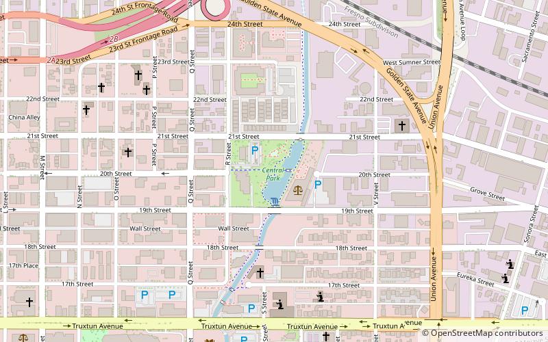
Central Park, Bakersfield
Map
Facts and practical information
Mill Creek is a linear park located in Bakersfield, California. It runs along the Kern Island Canal between Golden State Avenue and California Avenue in downtown, although there is a gap between 19th Street and the BNSF railroad yard. The center of the park is Central Park, the only park in downtown. The park contains a lake with spray fountains and the “Mill Creek” bridge. It is also home to the Bakersfield Museum of Art and the Bakersfield Community House. ()
Elevation: 407 ft a.s.l.Coordinates: 35°22'38"N, 119°0'29"W
Address
Central Bakersfield (Downtown Bakersfield)Bakersfield
ContactAdd
Social media
Add
Getting there by public transportation
Public transportation stops near this location
- Bus
- Train
 Bus
Bus
- Calculate routeBakersfield 9 min walk
- Calculate routeBakersfield, CA - Amtrak Station 10 min walk
- Calculate routeG 17 min walk
- Calculate routeGET Bus Station 17 min walk
- Calculate routeN 17 min walk
Day trips


Frequently Asked Questions (FAQ)
Which popular attractions are close to Central Park?
Nearby attractions include Bakersfield Museum of Art, Bakersfield (2 min walk), Kern Veterans Memorial, Bakersfield (8 min walk), Kern County Library, Bakersfield (9 min walk), Mechanics Bank Theater and Convention Center, Bakersfield (11 min walk).
How to get to Central Park by public transport?
The nearest stations to Central Park:
Train
Bus
Train
- Bakersfield (9 min walk)
Bus
- Bakersfield, CA - Amtrak Station • Lines: 10, 19 (10 min walk)
- G • Lines: 42 (17 min walk)