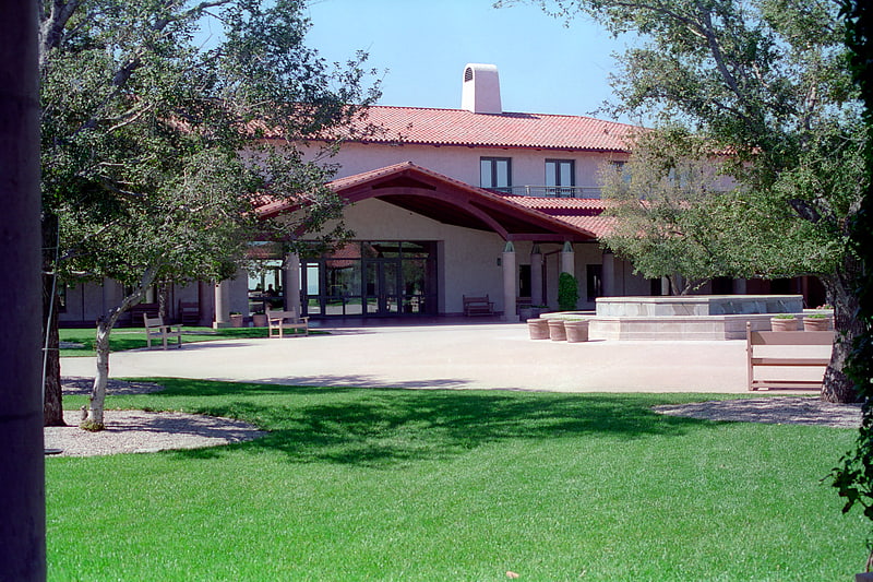
Lost Canyons Golf Club, Simi Valley
#2 among attractions in Simi Valley
![Lost Canyons Golf Club location map](https://tzmedia.b-cdn.net/media/images/static-maps/us/34_3138_-118_734.jpg)
Facts and practical information
Lost Canyons Golf Club was a public golf facility located in Simi Valley, California, USA. It has two 18-hole golf courses named Sky and Shadow. ()
3301 Lost Canyons DrSimi Valley 93063-7168 United States
Simi Valley plan & book
Unleash the traveler in you — discover the cheapest flight deals, find the perfect hotel or hostel nearby, and search for the best car rental prices. Travel at your own pace to discover new places and enjoy your journey.
Lost Canyons Golf Club – popular in the area (distance from the attraction)
Nearby attractions include: Reagan crypt, Corriganville Movie Ranch, Simi Valley Town Center, Simi Adobe–Strathearn House.
6.2 miSWMuseum, Library, Specialty museumReagan crypt, Simi Valley
158 min walk • The Reagan Crypt, nestled within the peaceful grounds of the Ronald Reagan Presidential Library and Museum in Simi Valley, Ventura County, California, serves as the final resting place of the 40th President of the United States, Ronald Reagan.
5.9 miSEParkCorriganville Movie Ranch, Simi Valley
150 min walk • Corriganville Movie Ranch was a working film studio and movie ranch for outdoor location shooting, as well as a Western-themed tourist attraction.
2.9 miSWShopping, Shopping centreSimi Valley Town Center, Simi Valley
74 min walk • Simi Valley Town Center is a lifestyle center located in Simi Valley, California. It was owned and operated by Forest City Enterprises. The mall was sold to Alberta Development Partners and Walton Street Capital in 2010.
4.7 miSWMuseum, Specialty museum, History museumSimi Adobe–Strathearn House, Simi Valley
119 min walk • The historic Simi Adobe–Strathearn House served as the headquarters of Rancho Simi, also known as Rancho San José de Nuestra Senora de Altagracia y Simi, one of the land grants in Alta California by the Spanish government. The name derives from Shimiji, the name of the Chumash village here before the Spanish.
2.9 miSEMuseum, Art museum, Vernacular architectureGrandma Prisbrey's Bottle Village, Simi Valley
74 min walk • Grandma Prisbrey's Bottle Village, also known as Bottle Village, is an art environment, located in Simi Valley, California. It was created by Tressa "Grandma" Prisbrey from the 1950s to the 1970s.
5.5 miSEMuseumSanta Susana Depot, Simi Valley
142 min walk • Santa Susana Depot is a train station building located near the Santa Susana Pass in Simi Valley, California. Originally located on Los Angeles Avenue at Tapo Street, the depot opened in 1903. The station was named after the Santa Susana Mountains at the east end of the Simi Valley.
5.3 miSWNature, Natural attraction, MountainMount McCoy, Simi Valley
137 min walk • Mount McCoy is a 1,325-foot-high peak in Simi Valley, California known for its characteristic 12 foot white cross on the top.
5.7 miSWParkChallenger Park, Simi Valley
145 min walk • Challenger Park is a 141.55-acre open-space park located in southern portion of Simi Valley, California in the Simi Hills. The park is owned and maintained by the Rancho Simi Recreation and Park District.
2.9 miS34°16'17"N • 118°44'13"WSimi Valley Cultural Arts Center, Simi Valley
75 min walk • Museum, Theater, Concerts and shows
5.1 miWParkOak Park, Simi Valley
132 min walk • Oak Park is a 100.5-acre open space regional park located at 901 Quisma Drive in Simi Valley, California, near Moorpark and California State Route 118. This county park, maintained by the Santa Monica Mountains Conservancy, is situated in the foothill country surrounded by rolling hills in the extreme west Simi Valley.
3.1 miSE