Peralta Hills, Yorba Linda
#6 among attractions in Yorba Linda
Facts and practical information
The Peralta Hills are a ridge of hills in northeastern Orange County, California. ()
Anaheim HillsYorba Linda United States
Peralta Hills – popular in the area (distance from the attraction)
Nearby attractions include: Honda Center, Richard Nixon Presidential Library and Museum, MainPlace Mall, The Village at Orange.
 Sport venue, Sport
Honda Center, Anaheim
149 min walk • The Honda Center is an indoor arena located in Anaheim, California. The arena is home to the Anaheim Ducks of the National Hockey League. Originally named the Anaheim Arena during construction, it was completed in 1993 at a cost of US$123 million. Arrowhead Water paid $15 million for the naming rights over 10 years in October 1993.
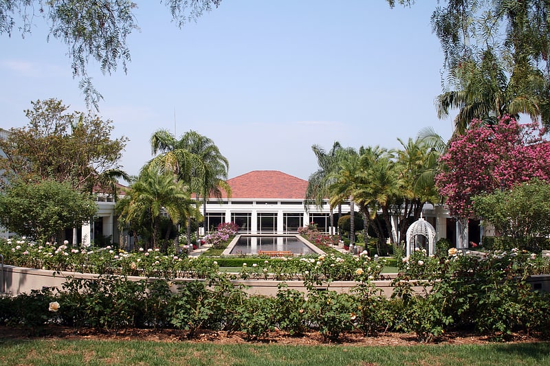
 Historical place, History museum, Museum
Richard Nixon Presidential Library and Museum, Yorba Linda
117 min walk • The Richard Nixon Presidential Library and Museum is the presidential library and burial site of Richard Milhous Nixon, the 37th president of the United States, and his wife Pat Nixon.
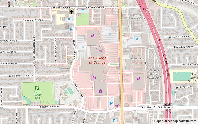
 Shopping, Shopping centre, Postmodern architecture
MainPlace Mall, Santa Ana
166 min walk • MainPlace Mall is a shopping mall at the north edge of Santa Ana, California, adjacent to the City of Orange and the Orange Crush interchange of the Santa Ana, Garden Grove and Orange freeways.
 Shopping, Shopping centre
The Village at Orange, Orange
86 min walk • The Village at Orange is a shopping mall located in Orange, California, formerly called The Mall of Orange and at first, officially the Orange Mall. The mall is currently anchored by Walmart on the north side.
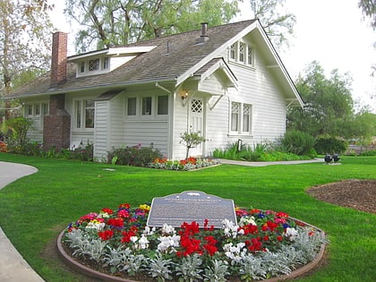 Historical place, History museum, Museum
Birthplace of Richard Nixon, Yorba Linda
116 min walk • The Richard Nixon Birthplace is the birthplace and early childhood home of Richard Nixon, the 37th president of the United States. It is located on the grounds of the Richard Nixon Presidential Library and Museum at 18001 Yorba Linda Boulevard in Yorba Linda, California, and serves as a historic house museum.
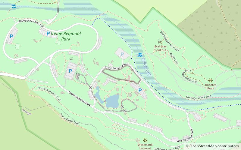 8 acres of native Southwestern animals
Orange County Zoo, Orange
76 min walk • The Orange County Zoo is a small 8-acre zoo located within the 477-acre Irvine Regional Park in the city of Orange, California, United States. The zoo is mainly home to animals and plants that are native to the Southwestern United States.
 Universities and schools, Church, Gothic Revival architecture
St. John's Lutheran Church, Orange
131 min walk • The St. John's Lutheran Church of Orange, California is a Lutheran church. The church was founded in 1882, and its sanctuary was built in 1913-14. The building was renovated and rededicated in 1990.
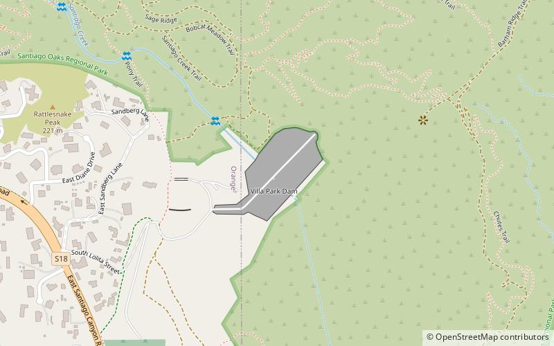 Dam
DamVilla Park Dam, Orange
37 min walk • Villa Park Dam is an embankment dam on Santiago Creek in Orange County, California in the United States. Along with the upstream Santiago Dam, the dam serves primarily for flood control for the cities of Villa Park, Orange, Tustin and Santa Ana and also regulates the inflow of Santiago Creek into the Santa Ana River.
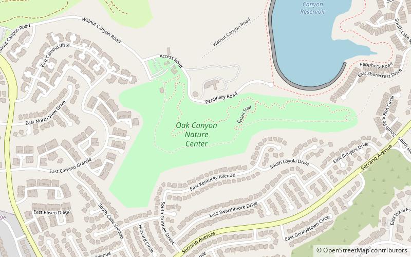 Park, Hiking trail, Waterfall
Oak Canyon Nature Center, Anaheim
38 min walk • Oak Canyon Nature Center is a nature preserve located in Anaheim, Southern California. Owned by the city, the park spans an area of 58-acres, comprising three adjoining canyons of the Santa Ana foothills.
 Reportedly haunted, Cemetery
Yorba Cemetery, Yorba Linda
58 min walk • Yorba Cemetery is a historic cemetery in Yorba Linda, California, originally part of Bernardo Yorba's Rancho Cañón de Santa Ana. It was deeded to the County of Orange in 1967. In 1858, the 40,000 square-foot plot of land was willed to the Catholic Church by Bernardo Yorba, as a burial ground to serve Yorba's family and friends.
 Neighbourhood
Old Towne, Orange
133 min walk • Old Towne, Orange Historic District, also known as Downtown Orange, is a one square-mile district around the original plaza of Orange, California, and contains many of the original structures built in the period after the city's incorporation.