Cameron Village, Baltimore
Map
Facts and practical information
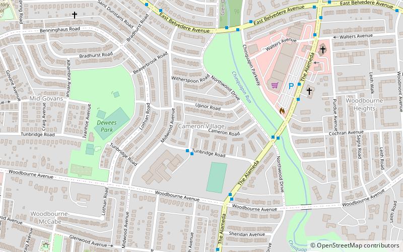
Cameron Village is a neighborhood in the North District of Baltimore, located between the neighborhoods of Mid-Govans and Woodbourne Heights. Vaguely bell-shaped, its boundaries are marked by Bradhurst Road and E. Belvedere Avenue, Woodbourne Avenue, Lothian Road and Northwood Drive. ()
Area: 87.68 acres (0.137 mi²)Coordinates: 39°21'24"N, 76°35'57"W
Address
Northern Baltimore (Cameron Village)Baltimore
ContactAdd
Social media
Add
Getting there by public transportation
Public transportation stops near this location
- Bus
 Bus
Bus
- Calculate routeYork Road & Woodbourne Avenue Northbound 15 min walk
Day trips


Frequently Asked Questions (FAQ)
Which popular attractions are close to Cameron Village?
Nearby attractions include Woodbourne Heights, Baltimore (13 min walk), Mid-Govans, Baltimore (15 min walk), Ramblewood, Baltimore (17 min walk), Govans, Baltimore (18 min walk).
How to get to Cameron Village by public transport?
The nearest stations to Cameron Village:
Bus
Bus
- York Road & Woodbourne Avenue Northbound • Lines: 52, Rd (15 min walk)