Sherman Circle, Washington D.C.
Map
Facts and practical information
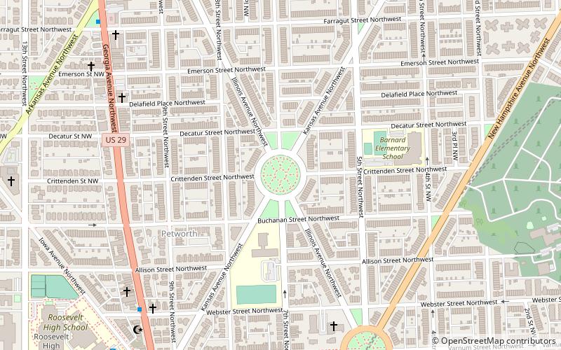
Sherman Circle is an urban park and traffic circle in the Northwest Washington, D.C. neighborhood of Petworth at the intersection of Illinois Avenue, Kansas Avenue, 7th Street, and Crittenden Street NW. The circle is named in honor of Civil War general William Tecumseh Sherman. Administered by the National Park Service's Rock Creek Park unit, Sherman Circle together with four surrounding triangular parks covers 3.44 acres and is considered by the National Park Service a "cultural landscape." ()
Elevation: 217 ft a.s.l.Coordinates: 38°56'50"N, 77°1'19"W
Address
Northwest Washington (Petworth)Washington D.C.
ContactAdd
Social media
Add
Getting there by public transportation
Public transportation stops near this location
- Metro
- Bus
 Metro
Metro
- Calculate routeGeorgia Avenue–Petworth 19 min walk
- Calculate routeFort Totten 28 min walk
- Calculate routeA 28 min walk
- Calculate routeK 28 min walk
- Calculate routeB 28 min walk
- Calculate routeC 28 min walk
Day trips
Sherman Circle – popular in the area (distance from the attraction)
Nearby attractions include: Petworth Library, United States Soldiers' and Airmen's Home National Cemetery, Grant Circle, St. Stephen and the Incarnation Episcopal Church.


Frequently Asked Questions (FAQ)
Which popular attractions are close to Sherman Circle?
Nearby attractions include Grant Circle, Washington D.C. (9 min walk), Petworth Library, Washington D.C. (10 min walk), Hampshire Garden Apartment Buildings, Washington D.C. (12 min walk), Brightwood Park, Washington D.C. (15 min walk).
How to get to Sherman Circle by public transport?
The nearest stations to Sherman Circle:
Metro
Bus
Metro
- Georgia Avenue–Petworth • Lines: Gr, Yl (19 min walk)
- Fort Totten • Lines: Gr, Rd, Yl (28 min walk)
Bus
- A • Lines: K6, K9 (28 min walk)
- K • Lines: 60, 64, E4, K2, K6, R1, R2 (28 min walk)