Rundle Park, Adelaide
Map
Facts and practical information
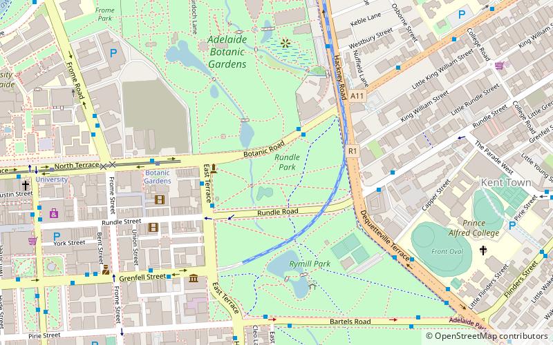
Rundle Park / Kadlitpina, also known as Park 13, is a part of the Adelaide Park Lands in Adelaide, South Australia. It was known as Rundle Park until its Kaurna name was assigned as part of the dual naming initiative by Adelaide City Council in 2003. The park is bounded by East Terrace, Botanic Road, Dequetteville Terrace and Rundle Road. ()
Elevation: 161 ft a.s.l.Coordinates: 34°55'17"S, 138°36'47"E
Address
Adelaide (Adelaide Park Lands)Adelaide
ContactAdd
Social media
Add
Getting there by public transportation
Public transportation stops near this location
- Bus
- Tram
- Train
 Bus
Bus
- Calculate routeBotanic Gardens 6 min walk
- Calculate routeUniversity 11 min walk
- Calculate routeArt Gallery 16 min walk
- Calculate routeRundle Mall Tram Stop 20 min walk
- Calculate routeStop F1 Grenfell Street - North side 19 min walk
- Calculate routeStop B1 King William Street - East side 20 min walk
- Calculate routeStop A3 King William Road - East side 20 min walk
- Calculate routeStop Z1 King William Street - West side 20 min walk
- Calculate routeAdelaide 24 min walk
Day trips


Frequently Asked Questions (FAQ)
Which popular attractions are close to Rundle Park?
Nearby attractions include National Wine Centre of Australia, Adelaide (4 min walk), Rymill Park, Adelaide (5 min walk), Ayers House, Adelaide (6 min walk), Tandanya National Aboriginal Cultural Institute, Adelaide (7 min walk).
How to get to Rundle Park by public transport?
The nearest stations to Rundle Park:
Tram
Bus
Train
Tram
- Botanic Gardens (6 min walk)
- University (11 min walk)
Bus
- Stop F1 Grenfell Street - North side • Lines: 830F (19 min walk)
- Stop B1 King William Street - East side • Lines: 719, 720, 720H, 721 (20 min walk)
Train
- Adelaide (24 min walk)