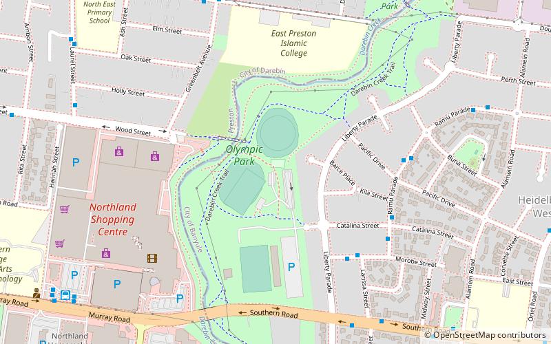
Olympic Park, Melbourne
Map
Facts and practical information
Olympic Park is located in Heidelberg West on the western fringe of the City of Banyule, was built for the 1956 Olympic Games in Melbourne, Australia. The park is an established sport and community recreation reserve with a significant history and was once used as a prominent training base for the 1956 Olympic Games. Olympic Park is home to Heidelberg United FC in the National Premier Leagues is now a high-profile soccer and cricket venue which also provides a range of other sport, recreation and open space opportunities. ()
Opened: 1956 (70 years ago)Capacity: 12 thous.Coordinates: 37°44'15"S, 145°2'6"E
Getting there by public transportation
Public transportation stops near this location
- Bus
- Tram
 Bus
Bus
- Calculate routeLiberty Pde 8 min walk
- Calculate routeSeston Street/Tyler Street 8 min walk
- Calculate routeWood Street/Laurel Street 10 min walk
- Calculate routeBlake Street/Seston Street 10 min walk
- Calculate routeStop 56: Loddon Avenue 26 min walk
- Calculate routeStop 57: Reservoir High School 27 min walk
- Calculate routeStop 55: Boldrewood Parade 27 min walk
Maps Melbourne TramsMaps
 Victoria Trains
Melbourne TramsMapsVictoria TrainsDay trips


Frequently Asked Questions (FAQ)
How to get to Olympic Park by public transport?
The nearest stations to Olympic Park:
Bus
Tram
Bus
- Liberty Pde • Lines: 517, 549 (8 min walk)
- Seston Street/Tyler Street • Lines: 567 (8 min walk)
Tram
- Stop 56: Loddon Avenue • Lines: 86, 86d (26 min walk)
- Stop 57: Reservoir High School • Lines: 86, 86d (27 min walk)