Menzies College, Melbourne
Map
Facts and practical information
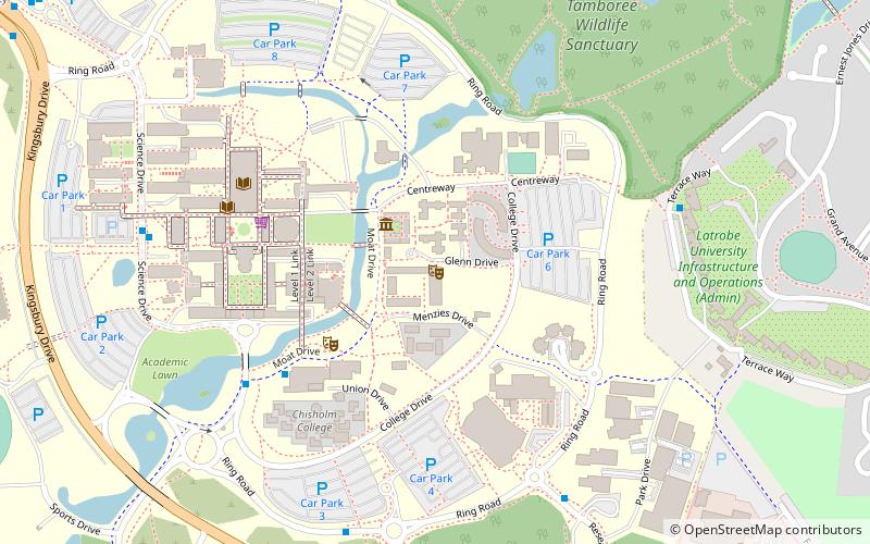
Menzies College is an Australian secular residential college for undergraduate students at La Trobe University, Bundoora campus. Established in 1968, Menzies College is named after Sir Robert Menzies, 12th Prime Minister of Australia and the nation's longest-serving prime minister. Menzies College is located on the eastern side of the Melbourne campus. The college is made up of single bedrooms with shared bathrooms and includes a café, fitness centre and gymnasium for use of the residents. Menzies College has a capacity of 385 residents. Dale Trendall, Australia's first Professor of Archaeology and La Trobe's only resident fellow lived at Menzies College from 1969 until his death in 1995. ()
Coordinates: 37°43'17"S, 145°3'8"E
Address
Banyule (Bundoora)Melbourne
ContactAdd
Social media
Add
Getting there by public transportation
Public transportation stops near this location
- Bus
- Tram
- Train
 Bus
Bus
- Calculate routeThomas Cherry Building 9 min walk
- Calculate routeLa Trobe University Medical Centre 16 min walk
- Calculate routePlenty Rd/Dunne St 17 min walk
- Calculate routePreston Cemetery 17 min walk
- Calculate routeStop 60: La Trobe University 16 min walk
- Calculate routeStop 61: Bundoora Park 18 min walk
- Calculate routeStop 59: Preston Cemetery 18 min walk
- Calculate routeStop 62: Bundoora Metropolitan Fire Brigade 20 min walk
- Calculate routeMacleod 25 min walk
Maps Melbourne TramsMaps
 Victoria Trains
Melbourne TramsMapsVictoria TrainsDay trips


Frequently Asked Questions (FAQ)
How to get to Menzies College by public transport?
The nearest stations to Menzies College:
Bus
Tram
Train
Bus
- Thomas Cherry Building • Lines: 250, 301, 350, 551, 561 (9 min walk)
- La Trobe University Medical Centre • Lines: 382, V405 (16 min walk)
Tram
- Stop 60: La Trobe University • Lines: 86, 86d (16 min walk)
- Stop 61: Bundoora Park • Lines: 86, 86d (18 min walk)
Train
- Macleod (25 min walk)