East Sydney, Sydney
Map
Facts and practical information
Coordinates: 33°52'31"S, 151°12'53"E
Address
Eastern Suburbs (Darlinghurst)Sydney
ContactAdd
Social media
Add
Getting there by public transportation
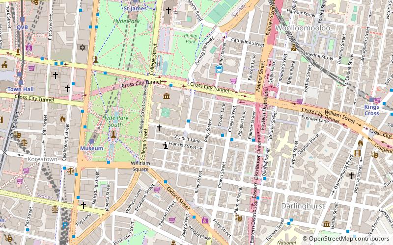
Public transportation stops near this location
- Bus
- Light rail
- Train
- Ferry
 Bus
Bus
- Calculate routeDomain Terminus 4 min walk
- Calculate routeMuseum Station, Elizabeth St, Stand D 8 min walk
- Calculate routeCastlereagh St before Bathurst St 9 min walk
- Calculate routeMuseum 7 min walk
- Calculate routeSt James 9 min walk
- Calculate routeKings Cross 12 min walk
- Calculate routeTown Hall 12 min walk
- Calculate routeTown Hall 12 min walk
- Calculate routeQvb 13 min walk
- Calculate routeChinatown 15 min walk
- Calculate routeCapitol Square 16 min walk
- Calculate routeDarling Harbour Wharf 1 26 min walk
- Calculate routeCircular Quay Wharf 2 27 min walk
- Calculate routePyrmont Bay Wharf 27 min walk
- Calculate routeCircular Quay Wharf 3 27 min walk
Maps Sydney TrainsMaps
 Sydney Light RailMaps
 Sydney Ferries
Sydney TrainsMapsSydney Light RailMapsSydney FerriesDay trips
East Sydney – popular in the area (distance from the attraction)
Nearby attractions include: Hyde Park, Australian Museum, St Mary's Cathedral, Cook and Phillip Park Aquatic and Fitness Centre.


Frequently Asked Questions (FAQ)
Which popular attractions are close to East Sydney?
Nearby attractions include Stanley Street Gallery, Sydney (1 min walk), Australian Museum, Sydney (3 min walk), Whitlam Square, Sydney (5 min walk), Emden Gun, Sydney (5 min walk).
How to get to East Sydney by public transport?
The nearest stations to East Sydney:
Bus
Train
Light rail
Ferry
Bus
- Domain Terminus (4 min walk)
- Museum Station, Elizabeth St, Stand D • Lines: 302, 303, 431 (8 min walk)
Train
- Museum (7 min walk)
- St James (9 min walk)
Light rail
- Town Hall • Lines: L2, L3 (12 min walk)
- Qvb • Lines: L2, L3 (13 min walk)
Ferry
- Darling Harbour Wharf 1 (26 min walk)
- Circular Quay Wharf 2 • Lines: F2, F7 (27 min walk)