White Bay Cruise Terminal, Sydney
Map
Facts and practical information
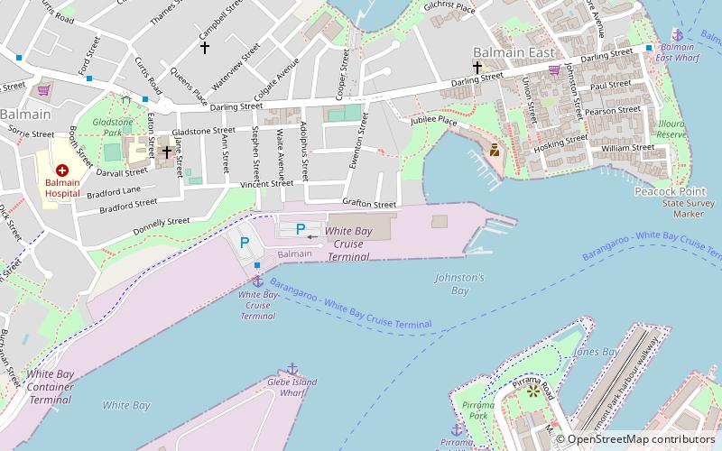
The White Bay Cruise Terminal is a terminal for cruise ships on Sydney Harbour. The terminal is located at the eastern end of the White Bay wharves, on the northern shore of White Bay. It opened on 15 April 2013 as a replacement for Wharf 8 on Darling Harbour which closed to make way for the Barangaroo development. ()
Coordinates: 33°51'38"S, 151°11'19"E
Address
Inner West (Balmain)Sydney
ContactAdd
Social media
Add
Getting there by public transportation
Public transportation stops near this location
- Bus
- Light rail
- Train
- Ferry
 Bus
Bus
- Calculate routeDarling St opp Gladstone Park 9 min walk
- Calculate routeGladstone Park, Darling St 10 min walk
- Calculate routeBalmain 12 min walk
- Calculate routeBalmain East Wharf 13 min walk
- Calculate routeBarangaroo, Wharf 1 19 min walk
- Calculate routeBlackwattle Bay Wharf 20 min walk
- Calculate routeJohn Street Square 13 min walk
- Calculate routeThe Star 16 min walk
- Calculate routeFish Market 19 min walk
- Calculate routePyrmont Bay 21 min walk
- Calculate routeWynyard 27 min walk
- Calculate routeTown Hall 35 min walk
Maps Sydney TrainsMaps
 Sydney Light RailMaps
 Sydney Ferries
Sydney TrainsMapsSydney Light RailMapsSydney FerriesDay trips


Frequently Asked Questions (FAQ)
Which popular attractions are close to White Bay Cruise Terminal?
Nearby attractions include Ewenton, Sydney (4 min walk), Iloura Reserve, Sydney (12 min walk), Sydney Fish Market, Sydney (14 min walk), Glebe Island Bridge, Sydney (14 min walk).
How to get to White Bay Cruise Terminal by public transport?
The nearest stations to White Bay Cruise Terminal:
Bus
Ferry
Light rail
Train
Bus
- Darling St opp Gladstone Park • Lines: 433 (9 min walk)
- Gladstone Park, Darling St • Lines: 433 (10 min walk)
Ferry
- Balmain (12 min walk)
- Balmain East Wharf • Lines: F4 (13 min walk)
Light rail
- John Street Square • Lines: L1 (13 min walk)
- The Star • Lines: L1 (16 min walk)
Train
- Wynyard (27 min walk)
- Town Hall (35 min walk)