First Church of Christ, Vancouver
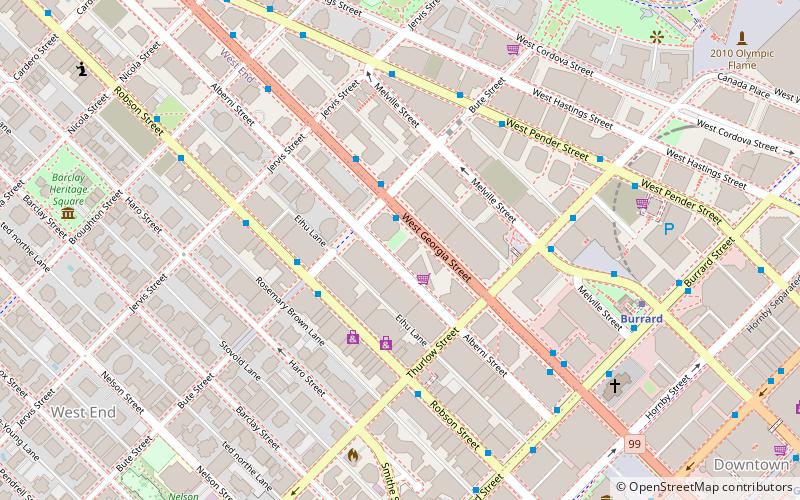
Map
Facts and practical information
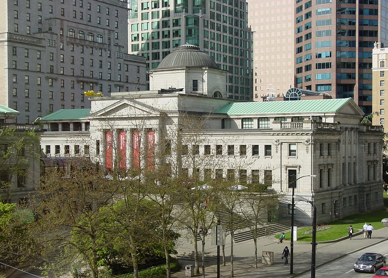
The former First Church of Christ, Scientist is an historic Christian Science church edifice located at 1160 Georgia Street in the west end of Vancouver, British Columbia, Canada. It was designed in the Colonial Revival style by the noted Vancouver architectural firm of Matheson and De Guerre. Built in 1918, it is a two-storey brick building with basement. In 2002, First Church of Christ, Scientist sold its building to Coastal Church. On December 20, 2003, The city of Vancouver designated the building a local Heritage site. ()
Coordinates: 49°17'11"N, 123°7'30"W
Address
West EndVancouver
ContactAdd
Social media
Add
Getting there by public transportation
Public transportation stops near this location
- Metro
- Bus
- Trolleybus
- Train
- Ferry
 Metro
Metro
- Calculate routeWest Georgia Street at Bute Street 2 min walk
- Calculate routeBurrard Station Bay 3 4 min walk
- Calculate routeBurrard Station Bay 2 6 min walk
- Calculate routeRobson St at Bute St 3 min walk
- Calculate routeWest Pender St at Bute St 4 min walk
- Calculate routeBurrard 7 min walk
- Calculate routeVancouver City Centre 11 min walk
- Calculate routeGranville 13 min walk
- Calculate routeWaterfront 15 min walk
- Calculate routeWaterfront 16 min walk
- Calculate routeWaterfront 19 min walk
- Calculate routeAquatic Centre Dock 22 min walk
- Calculate routeHornby Terminal 24 min walk
- Calculate routeGranville Island Dock 27 min walk
Maps SkyTrain
SkyTrainDay trips
First Church of Christ – popular in the area (distance from the attraction)
Nearby attractions include: Robson Street, Commodore Ballroom, Vancouver Art Gallery, Pacific Centre.


Frequently Asked Questions (FAQ)
Which popular attractions are close to First Church of Christ?
Nearby attractions include Trump International Hotel and Tower, Vancouver (2 min walk), The Melville, Vancouver (3 min walk), Christ Church Cathedral, Vancouver (7 min walk), King Edward VII fountain, Vancouver (8 min walk).
How to get to First Church of Christ by public transport?
The nearest stations to First Church of Christ:
Bus
Trolleybus
Metro
Train
Ferry
Bus
- West Georgia Street at Bute Street • Lines: 240, 246, 250 (2 min walk)
- Burrard Station Bay 3 • Lines: 22 (4 min walk)
Trolleybus
- Robson St at Bute St • Lines: 5 (3 min walk)
- West Pender St at Bute St • Lines: 19 (4 min walk)
Metro
- Burrard • Lines: Expo Line (7 min walk)
- Vancouver City Centre • Lines: Canada Line (11 min walk)
Train
- Waterfront (16 min walk)
Ferry
- Waterfront • Lines: SeaBus (19 min walk)
- Aquatic Centre Dock • Lines: False Creek Ferries Route 1, False Creek Ferries Route 2 (22 min walk)