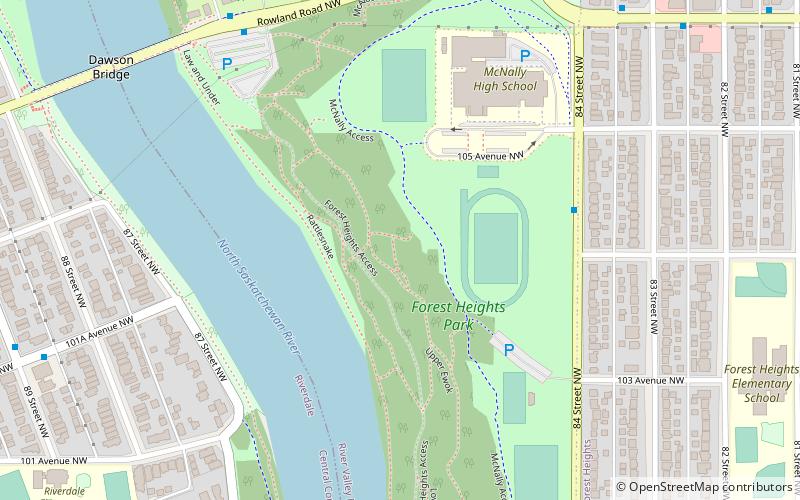
Forest Heights Park, Edmonton
Map
Facts and practical information
Forest Heights Park is a municipal park in Edmonton, Alberta, Canada, and is one of the largest parks in the Edmonton North Saskatchewan valley parks system. It overlooks the North Saskatchewan River, as well as downtown Edmonton. The park is mostly located in the Forest Heights neighborhood. ()
Elevation: 2126 ft a.s.l.Coordinates: 53°32'47"N, 113°27'40"W
Address
South Central Edmonton (River Valley Riverside)Edmonton
ContactAdd
Social media
Add
Getting there by public transportation
Public transportation stops near this location
- Bus
- Light rail
 Bus
Bus
- Calculate routeDawson Bridge & Rowland Road 7 min walk
- Calculate route83 Street & 106 Ave 8 min walk
- Calculate route89 Street & Rowland Road 11 min walk
- Calculate route81 Street & 106 Ave 11 min walk
- Calculate routeStadium 26 min walk
- Calculate routeChurchill 30 min walk
Day trips


Frequently Asked Questions (FAQ)
Which popular attractions are close to Forest Heights Park?
Nearby attractions include Dawson Bridge, Edmonton (8 min walk), Forest Heights, Edmonton (12 min walk), Tawatinâ Bridge, Edmonton (21 min walk), Grierson Centre, Edmonton (21 min walk).
How to get to Forest Heights Park by public transport?
The nearest stations to Forest Heights Park:
Bus
Light rail
Bus
- Dawson Bridge & Rowland Road • Lines: 1 (7 min walk)
- 83 Street & 106 Ave • Lines: 1 (8 min walk)
Light rail
- Stadium • Lines: 501 (26 min walk)
- Churchill • Lines: 501, 502 (30 min walk)