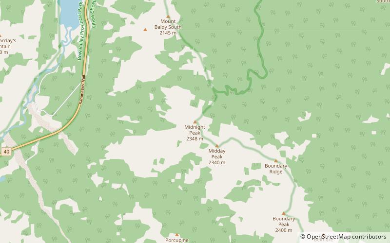
Midnight Peak, Elbow-Sheep Wildland Provincial Park
#12 among attractions in Elbow-Sheep Wildland Provincial Park
![Midnight Peak location map](https://tzmedia.b-cdn.net/media/images/static-maps/ca/50_9798_-115_03533.jpg)
Facts and practical information
Midnight Peak is located in the Kananaskis River valley along Highway 40 in the Canadian Rockies of Alberta. ()
Elbow-Sheep Wildland Provincial Park Canada
Elbow-Sheep Wildland Provincial Park plan & book
Unleash the traveler in you — discover the cheapest flight deals, find the perfect hotel or hostel nearby, and search for the best car rental prices. Travel at your own pace to discover new places and enjoy your journey.
Midnight Peak – popular in the area (distance from the attraction)
Nearby attractions include: Golf Course, Nakiska, Barrier Lake, Heart Mountain.
7.2 miSWGolfGolf Course, Kananaskis Country
183 min walk • Kananaskis Country Golf Course is a public 36-hole golf course situated in Kananaskis Country, a park system west of Calgary, Alberta, Canada in the foothills and front ranges of the Canadian Rockies.
5.4 miSWWinter sport, Ski areaNakiska
139 min walk • Nakiska is a ski resort in western Canada, in the Kananaskis Country region of the province of Alberta. It is located 83 km from Calgary, west on Highway 1 and south on Highway 40. "Nakiska" is a Cree word meaning "to meet" or "meeting...
3.2 miNNature, Natural attraction, LakeBarrier Lake
83 min walk • Barrier Lake is a man made reservoir at the north end of Kananaskis Country in Alberta, Canada. Highway 40 runs between the lake and Mount Baldy, on the eastern shore. It is entirely located in the Bow Valley Provincial Park. Barrier Lake was created for hydroelectric power generation on the Kananaskis River.
6 miNWNature, Natural attraction, MountainHeart Mountain
155 min walk • Heart Mountain is a mountain located in the Bow River valley just south of Exshaw, Alberta. The peak was named in 1957 for the heart shaped layer of limestone near the top.
2.4 miNNature, Natural attraction, MountainMount Baldy
61 min walk • Mount Baldy is a mountain located in the Kananaskis River valley alongside Highway 40 in the Canadian Rockies. During World War II, prisoners in a nearby internment camp were occasionally permitted to make the ascent of Mt.
3.6 miSWMountainWasootch Peak, Kananaskis Country
93 min walk • Wasootch Peak is a 2,352-metre mountain summit located in the Fisher Range of Kananaskis Country in the Canadian Rockies of Alberta, Canada.
5.9 miENature, Natural attraction, MountainJumpingpound Mountain
151 min walk • Jumpingpound Mountain is a mountain located 24 km west of Bragg Creek, Alberta in Kananaskis Country. It was named after Jumpingpound Creek in 1949 because a steep bank near the mouth was used as a buffalo jump by the Blackfoot First Nations.
5.1 miNParkBow Valley Provincial Park
132 min walk • Bow Valley Provincial Park is a provincial park in Alberta, Canada. Established in 1959 in the arch of the Bow River at its confluence with the Kananaskis River, the park is one park of many within the Kananaskis Country park system.
5.8 miSMountainMount Bryant, Elbow-Sheep Wildland Provincial Park
147 min walk • Mount Bryant is a mountain in the Fisher Range in the Rocky Mountains of Alberta. Named for Alfred Harold Bryant, a homesteader from the surrounding area who later became a forest ranger.