Misty Range, Elbow-Sheep Wildland Provincial Park
#17 among attractions in Elbow-Sheep Wildland Provincial Park

Facts and practical information
The Misty Range is a mountain range of the Canadian Rockies located east of the Bighorn Highway within Kananaskis Country, Canada. ()
Elbow-Sheep Wildland Provincial Park Canada
Elbow-Sheep Wildland Provincial Park plan & book
Unleash the traveler in you — discover the cheapest flight deals, find the perfect hotel or hostel nearby, and search for the best car rental prices. Travel at your own pace to discover new places and enjoy your journey.
Misty Range – popular in the area (distance from the attraction)
Nearby attractions include: Elbow Lake, Highwood Pass, Mount Tyrwhitt, Gap Mountain.
 Nature, Natural attraction, Lake
Elbow Lake
92 min walk • Nestled in the heart of Canada's picturesque wilderness, Elbow Lake offers a serene escape for nature enthusiasts and adventure seekers alike. This pristine lake is a shimmering jewel amidst the rugged beauty of the Canadian landscape, providing a tranquil retreat from...
 Mountain pass
Highwood Pass
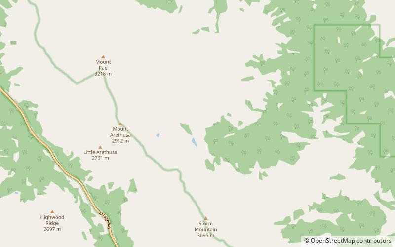
57 min walk • Highwood Pass is a mountain pass in Kananaskis Country, Alberta, Canada. It lies west of Mount Rae and Mount Arethusa of the Misty Range, south of the Elbow Pass. It lies within the Peter Lougheed Provincial Park on Alberta Highway 40. The Highwood River originates in the pass.
 Nature, Natural attraction, Mountain
Mount Tyrwhitt
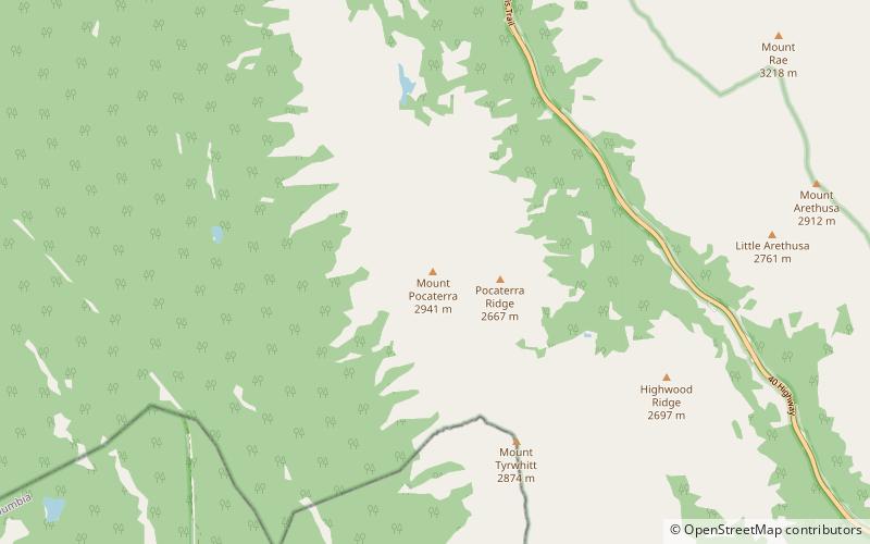
95 min walk • Mount Tyrwhitt is a mountain in British Columbia and Alberta, Canada located between Highway 40 and Elk Pass in the Elk Range of the Canadian Rockies, west of the Highwood Pass parking lot in Kananaskis Country and south east of Upper Kananaskis Lake.
 Mountain
Gap Mountain
152 min walk • Gap Mountain is a 2,675-metre mountain summit located at the southern end of the Opal Range in the Canadian Rockies of Alberta, Canada. Its nearest higher peak is Elpoca Mountain, 2.0 km to the east. Gap Mountain is situated 5.0 km south of Mount Wintour, within Peter Lougheed Provincial Park.
 Nature, Natural attraction, Mountain
Mist Mountain
102 min walk • Mist Mountain is a mountain located alongside Highway 40 in the Canadian Rockies of Alberta, Canada. It reaches an elevation of 3,140 m and is visible from Alberta Highway 40 and the Sheep River. The mountain was named in 1884 by George M. Dawson.
 Mountain
Elpoca Mountain, Elbow-Sheep Wildland Provincial Park
138 min walk • Elpoca Mountain is a 3,036-metre mountain summit located at the southern end of the Opal Range in the Canadian Rockies of Alberta, Canada. Its nearest higher peak is Mount Evan-Thomas, 12.0 km to the north.
 Natural attraction, Mountain, Hiking trail
Ptarmigan Cirque
46 min walk • Ptarmigan Cirque is the cirque between Mount Arethusa and Mount Rae at the Highwood Pass in Kananaskis Country, Alberta, Canada. The Ptarmigan Cirque hiking trail is a short loop in the cirque.
 Nature, Natural attraction, Mountain
Mount Rae
46 min walk • Mount Rae is a mountain located on the east side of Highway 40 between Elbow Pass and the Ptarmigan Cirque in the Canadian Rockies of Alberta. Mount Rae was named after John Rae, explorer of Northern Canada, in 1859.
 Nature, Natural attraction, Mountain
Mount Pocaterra
99 min walk • Mount Pocaterra is the unofficial name of a rocky formation named after the Pocaterra Creek in the same region. It is located in the Elk Range in Alberta. This peak is located on the crest of a ridge, about 1.5 km north of the lower Mount Tyrwhitt. The peak is a double summit, with the north summit slightly higher.
 Mountain
Storelk Mountain, Elbow-Sheep Wildland Provincial Park
131 min walk • Storelk Mountain is located on the border of Alberta and British Columbia on the Continental Divide. It was named in 1915.
 Nature, Natural attraction, Mountain
Mount Arethusa
31 min walk • Mount Arethusa is a mountain located in the Canadian Rockies of Alberta, Canada. It is located alongside Highway 40, immediately east of the Highwood Pass parking lot in Kananaskis Country, and is a part of the Misty Range of the Southern Continental Ranges.


