Fort d'Ivry, Montreuil
Map
Facts and practical information
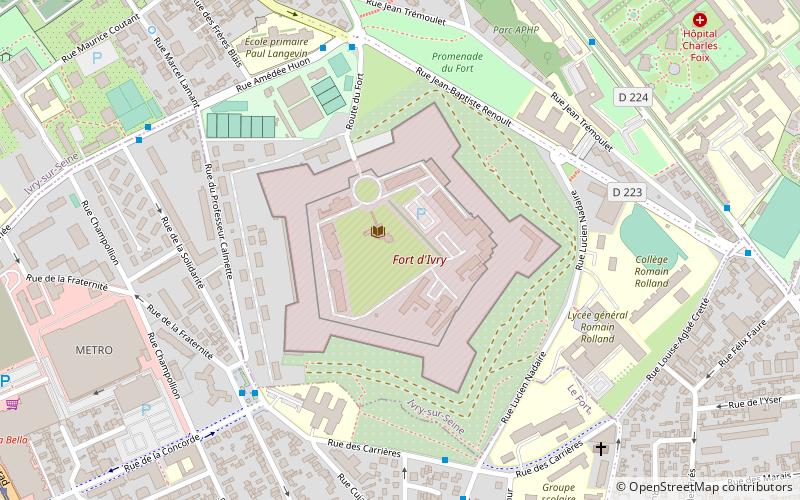
Fort d'Ivry was built in the Paris suburb of Ivry-sur-Seine between 1841 and 1845, as one of the forts in a ring of strong points surrounding Paris. The fort is about 1 kilometre outside the Thiers Wall, built by the same program in response to a perception that Paris was vulnerable to invasion and occupation. The fort was upgraded in the 1870s, to cope with improvements in artillery performance as part of the Séré de Rivières system. In 1946, the fort was vacated by the garrison. It is now the home of the Communication and Audiovisual Production Company for the Department of Defense. ()
Address
Ivry-sur-Seine (Centre - Parmentier - Fort)Montreuil
ContactAdd
Social media
Add
Getting there by public transportation
Public transportation stops near this location
- Metro
- Bus
- Tram
- Train
 Metro
Metro
- Calculate routePlace de la Liberté 6 min walk
- Calculate routeFort d'Ivry 6 min walk
- Calculate routeLavoisier - Carrières 6 min walk
- Calculate routeSolidarité - Amédée Huon 7 min walk
- Calculate routeBeethoven - Concorde 12 min walk
- Calculate routeGermaine Tailleferre 15 min walk
- Calculate routeMusée MAC VAL 18 min walk
- Calculate routeLa Briqueterie 20 min walk
- Calculate routeVitry sur Seine 15 min walk
- Calculate routeIvry-sur-Seine 22 min walk
- Calculate routeMairie d'Ivry 17 min walk
- Calculate routePierre et Marie Curie 29 min walk
- Calculate routeVillejuif - Louis Aragon 38 min walk
Day trips


Frequently Asked Questions (FAQ)
Which popular attractions are close to Fort d'Ivry?
Nearby attractions include Exploradôme, Paris (17 min walk), Musée d'Art Contemporain du Val-de-Marne, Paris (17 min walk), Ivry-sur-Seine, Paris (21 min walk).
How to get to Fort d'Ivry by public transport?
The nearest stations to Fort d'Ivry:
Bus
Tram
Train
Metro
Bus
- Place de la Liberté • Lines: 132 (6 min walk)
- Fort d'Ivry • Lines: 132 (6 min walk)
Tram
- Beethoven - Concorde • Lines: T9 (12 min walk)
- Germaine Tailleferre • Lines: T9 (15 min walk)
Train
- Vitry sur Seine (15 min walk)
- Ivry-sur-Seine (22 min walk)
Metro
- Mairie d'Ivry • Lines: 7 (17 min walk)
- Pierre et Marie Curie • Lines: 7 (29 min walk)