
Pico Pijol National Park Travel Guide
Facts and practical information
Nestled in the picturesque Yoro region of Honduras, Pico Pijol National Park is a nature lover's paradise waiting to be explored. This stunning national park is home to lush rainforests, cascading waterfalls, and diverse wildlife, making it the perfect destination for outdoor enthusiasts and adventure seekers.
One of the highlights of Pico Pijol National Park is the towering peak of Pico Pijol, which offers breathtaking panoramic views of the surrounding landscape. Hiking to the summit is a popular activity for visitors, providing a challenging yet rewarding experience. The park is also crisscrossed with a network of hiking trails, allowing visitors to immerse themselves in the natural beauty of the park and discover its hidden gems.
For those interested in wildlife, Pico Pijol National Park is home to a rich variety of flora and fauna. Birdwatchers will be delighted by the opportunity to spot colorful tropical birds, while nature enthusiasts can marvel at the diverse plant life that thrives within the park. The park is also home to a number of unique animal species, including howler monkeys and elusive jaguars.
In addition to its natural beauty, Pico Pijol National Park is also a place of cultural significance. The park is dotted with archaeological sites that offer a glimpse into the ancient history of the region, providing a fascinating contrast to the natural wonders that abound.
Yoro
Best Time To Visit Pico Pijol National Park
Learn when is the best time to travel to Pico Pijol National Park weather-wise and what to expect in each season.
Best Ways to Experience the Park
Wildlife
AnimalsSee what popular animal species you can meet in this location.
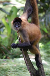
Black-handed Spider Monkey
Geoffroy’s spider monkey, also known as the black-handed spider monkey or Central American spider monkey, is a captivating New World primate native to Central America, parts of Mexico, and possibly a small region in Colombia.
Mammals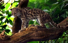
Margay
The margay is a small wild cat native to the primary forests of Central and South America. Unfortunately, it was heavily hunted for the wildlife trade until the 1990s, which led to a significant decline in its population.
Mammals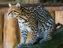
Ocelot
The ocelot is a small wild cat that inhabits the southwestern United States, Mexico, and parts of Central and South America. It is easily recognizable by its striking coat, adorned with solid black spots and streaks, as well as its round ears and white neck...
Mammals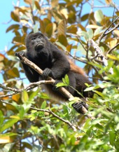
Mantled Howler Monkey
The mantled howler, also known as the golden-mantled howling monkey, is a captivating species of New World monkey found in Central and South America. As one of the largest monkeys in Central America, it is renowned for its predominantly leaf-based diet and unique...
Mammals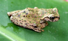
Guatemala Spikethumb Frog
The Guatemala spikethumb frog, scientifically known as *Plectrohyla guatemalensis*, is a captivating amphibian belonging to the Hylidae family. This diminutive creature inhabits the highlands of the Sierra Madre region. Its range extends from southeastern Chiapas in...
Amphibians