Cupidstown Hill
#475 among destinations in Ireland
Facts and practical information
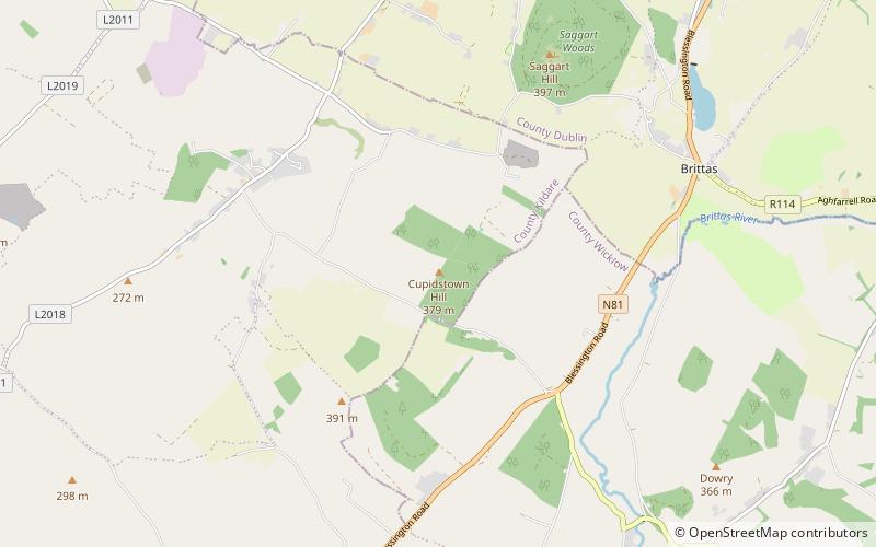
Cupidstown Hill, at 379 metres, is the highest point in County Kildare, Ireland, and lies on the fringes of the Wicklow Mountains, 11.6 kilometres east of Naas. ()
KildareIreland
Cupidstown Hill plan & book
Unleash the traveler in you — discover the cheapest flight deals, find the perfect hotel or hostel nearby, and search for the best car rental prices. Travel at your own pace to discover new places and enjoy your journey.
Cupidstown Hill – popular in the area (distance from the attraction)
Nearby attractions include: The Square Tallaght, Tallaght Stadium, K Club, Seefin.
- 6.6 miNEShopping, Shopping centre
The Square Tallaght, Dublin
168 min walk • The Square Tallaght stands as a bustling hub of retail and social activity in the heart of Dublin's southwestern suburb of Tallaght. This expansive shopping centre, which first opened its doors in 1990, has grown to become one of the city's premier destinations for...
- 6.4 miNESport venue, Sport, Football
Tallaght Stadium, Dublin
163 min walk • Tallaght Stadium is an association football stadium in the Republic of Ireland based in Tallaght, South Dublin. The club Shamrock Rovers originally announced details of the stadium in July, 1996.
- 7.7 miNWSport, Sport venue
K Club, Straffan
198 min walk • The Kildare Hotel and Golf Club is a golf and leisure complex in the Republic of Ireland, located at Straffan, County Kildare, west of Dublin. It is built on the original grounds of the Straffan estate, incorporating the 1830s Straffan House, and was owned by Michael Smurfit.
- 5 miSEMuseum, Archaeological site
Seefin, Wicklow Mountains National Park
128 min walk • Seefin Passage Tomb is a passage grave and National Monument located atop Seefin Hill, County Wicklow, Ireland.
- 5.5 miSENature, Natural attraction, Mountain
Seefingan, Wicklow Mountains National Park
141 min walk • Seefingan often spelt Seafingan is a mountain that straddles two county boundaries from its summit in Wicklow eastwards down into South Dublin, in Ireland. There are extensive views from the summit and there is a large megalithic cairn nearby.
- 4.1 miSWArchaeological site
Rath Turtle Moat
106 min walk • Rath Turtle Moat is a ringwork and National Monument located in County Wicklow, Ireland.
- 4.6 miNWCemetery
Oughter Ard
118 min walk • Oughterard is an ecclesiastical hilltop site, graveyard, townland, and formerly a parish, borough and royal manor in County Kildare, nowadays part of the community of Ardclough, close to the Dublin border. It is the burial place of Arthur Guinness.
- 6.4 miNE
- 4.4 miWArchaeological site
Furness Church
113 min walk • Furness Church is a 13th-century Norman church located in County Kildare, Ireland.
- 6.8 miSWForts and castles
Barretstown Castle
174 min walk • Barretstown Castle is a castle in Ballymore Eustace, County Kildare, Ireland. It stands on the site of a late 12th century Anglo-Norman castle. It now hosts the Barretstown camp for sick children.
- 3.1 miSRuins
Threecastles Castle
79 min walk • Threecastles Castle is a National Monument situated in Blessington, County Wicklow, Ireland.