Vatican City, Rome
Facts and practical information
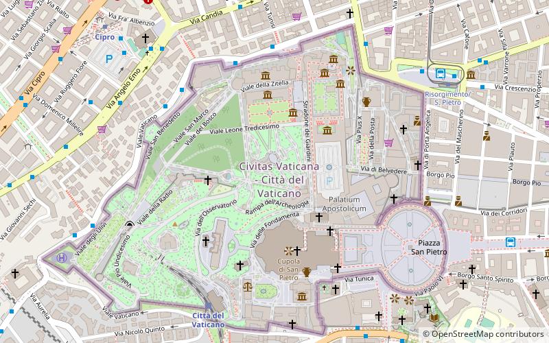
Vatican City, officially the Vatican City State, is an independent city-state and enclave surrounded by Rome, Italy. The Vatican City State, also known simply as the Vatican, became independent from Italy with the Lateran Treaty, and it is a distinct territory under "full ownership, exclusive dominion, and sovereign authority and jurisdiction" of the Holy See, itself a sovereign entity of international law, which maintains the city state's temporal, diplomatic, and spiritual independence. With an area of 49 hectares and a population of about 825, it is the smallest state in the world by both area and population. As governed by the Holy See, the Vatican City State is an ecclesiastical or sacerdotal-monarchical state ruled by the pope who is the bishop of Rome and head of the Catholic Church. The highest state functionaries are all Catholic clergy of various national origins. After the Avignon Papacy the popes have mainly resided at the Apostolic Palace within what is now Vatican City, although at times residing instead in the Quirinal Palace in Rome or elsewhere. ()
- Metro
- Bus
- Tram
- Train
- Ferry
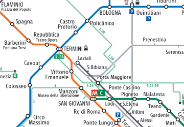
 Metro
Metro
- Calculate routeV.le Vaticano/Musei Vaticani 5 min walk
- Calculate routeBastioni di Michelangelo 7 min walk
- Calculate routeCandia/Mocenigo 7 min walk
- Calculate routeVatican City 7 min walk
- Calculate routeRoma San Pietro 15 min walk
- Calculate routeValle Aurelia 15 min walk
- Calculate routeAppiano 24 min walk
- Calculate routeRisorgimento/S. Pietro 8 min walk
- Calculate routeOttaviano 13 min walk
- Calculate routeMilizie/Distretto Militare 18 min walk
- Calculate routeCipro 10 min walk
- Calculate routeOttaviano 12 min walk
- Calculate routeValle Aurelia 16 min walk
- Calculate routeLepanto 22 min walk
- Calculate routeSant'Angelo 21 min walk
- Calculate routePonte Cavour 28 min walk
- Calculate routeIsola Tiberina 39 min walk
 Metro / Tram / Rail


Frequently Asked Questions (FAQ)
Which popular attractions are close to Vatican City?
How to get to Vatican City by public transport?
Bus
- V.le Vaticano/Musei Vaticani • Lines: 49 (5 min walk)
- Bastioni di Michelangelo • Lines: 23, 492 (7 min walk)
Train
- Vatican City (7 min walk)
- Roma San Pietro (15 min walk)
Tram
- Risorgimento/S. Pietro • Lines: 19 (8 min walk)
- Ottaviano • Lines: 19 (13 min walk)
Metro
- Cipro • Lines: A (10 min walk)
- Ottaviano • Lines: A (12 min walk)
Ferry
- Sant'Angelo • Lines: Battelli di Roma (21 min walk)
- Ponte Cavour (28 min walk)