Victoria Park Tunnel, Auckland
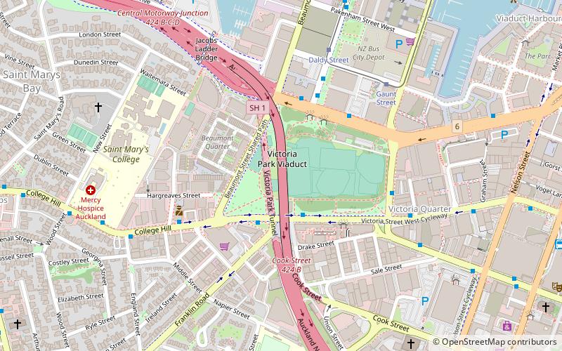
Map
Facts and practical information
The Victoria Park Tunnel is a motorway tunnel completed in 2012 on New Zealand State Highway 1 in Auckland, New Zealand, taking northbound traffic off the Victoria Park Viaduct, which was converted to all southbound traffic. It lies mostly under Victoria Park. ()
Coordinates: 36°50'49"S, 174°45'11"E
Address
Central Auckland (Auckland Central Business District)Auckland
ContactAdd
Social media
Add
Getting there by public transportation
Public transportation stops near this location
- Bus
- Tram
- Train
- Ferry
 Bus
Bus
- Calculate routeVictoria Street West / Franklin Road 3 min walk
- Calculate routeFanshawe Street / Victoria Park 3 min walk
- Calculate routeFanshawe Street / Daldy Street 4 min walk
- Calculate routeDaldy Street 6 min walk
- Calculate routeGaunt Street 7 min walk
- Calculate routeJellicoe Street 12 min walk
- Calculate routeHalsey Street 13 min walk
- Calculate routeSealink Hamer Street 16 min walk
- Calculate routeDowntown Pier 14 20 min walk
- Calculate routeDowntown Pier 11 21 min walk
- Calculate routeDowntown Pier 1 22 min walk
- Calculate routeBritomart 23 min walk
Day trips


Frequently Asked Questions (FAQ)
Which popular attractions are close to Victoria Park Tunnel?
Nearby attractions include Victoria Park Viaduct, Auckland (1 min walk), Victoria Park, Auckland (2 min walk), Allpress Studio Auckland, Auckland (5 min walk), Jacobs Ladder Bridge, Auckland (7 min walk).
How to get to Victoria Park Tunnel by public transport?
The nearest stations to Victoria Park Tunnel:
Bus
Tram
Ferry
Train
Bus
- Victoria Street West / Franklin Road • Lines: 101, Inn, Out (3 min walk)
- Fanshawe Street / Victoria Park • Lines: 82, 923, 924, 931, 933, 95B, 95C, 97B, Nx1, Nx2 (3 min walk)
Tram
- Daldy Street • Lines: Wynyard Loop (6 min walk)
- Gaunt Street • Lines: Wynyard Loop (7 min walk)
Ferry
- Sealink Hamer Street (16 min walk)
- Downtown Pier 14 (20 min walk)
Train
- Britomart (23 min walk)