Sengkang Riverside Park, Singapore/East Coast

Gallery (1)
Map
Map
Facts and practical information
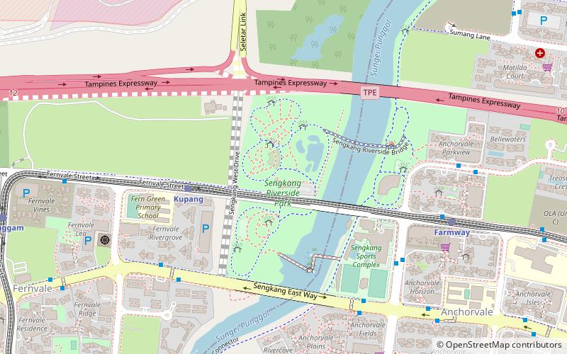
Sengkang Riverside Park is a riverine park located at Anchorvale Street and Fernvale Street abutting Sungei Punggol, Singapore. The park consist of three open-space land parcels and is also home to a constructed wetland. The Sengkang Sports Centre is located just adjacent to the riverine park, connected by a floating wetland. ()
Elevation: 36 ft a.s.l.Coordinates: 1°23'55"N, 103°53'3"E
Address
Northeast Region (Sengkang)Singapore/East Coast
ContactAdd
Social media
Add
Getting there by public transportation
Public transportation stops near this location
- Metro
- Bus
- Train
 Metro
Metro
- Calculate routeKupang 6 min walk
- Calculate routeFarmway 10 min walk
- Calculate routeLayar 14 min walk
- Calculate routeThanggam 16 min walk
- Calculate routeOpposite Blk 326D 8 min walk
- Calculate routeBlk 326D 8 min walk
- Calculate routeOpposite Blk 471A 8 min walk
- Calculate routeHockey Stadium 8 min walk
- Calculate routeSengkang 24 min walk
- Calculate routeBuangkok 32 min walk
Maps Metro
Metro
MetroDay trips


Frequently Asked Questions (FAQ)
Which popular attractions are close to Sengkang Riverside Park?
Nearby attractions include Anchorvale (14 min walk), Sengkang Public Library (23 min walk), Sengkang Sculpture Park (24 min walk).
How to get to Sengkang Riverside Park by public transport?
The nearest stations to Sengkang Riverside Park:
Train
Bus
Metro
Train
- Kupang (6 min walk)
- Farmway (10 min walk)
Bus
- Opposite Blk 326D • Lines: 110, 374 (8 min walk)
- Blk 326D • Lines: 110, 374 (8 min walk)
Metro
- Sengkang • Lines: Nel (24 min walk)
- Buangkok • Lines: Nel (32 min walk)