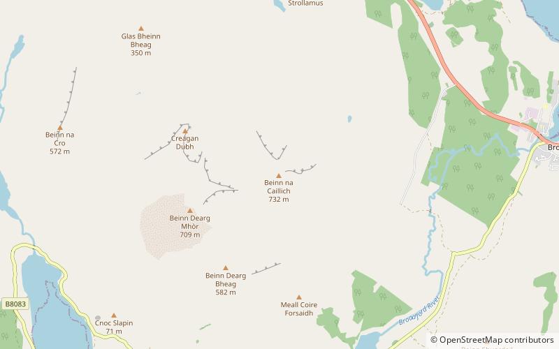
Beinn na Caillich, Broadford
#1 among attractions in Broadford
Facts and practical information
Beinn na Caillich, west of Broadford on the Isle of Skye, is one of the Red Hills, or Red Cuillin. Its name is translated into English as Hill of the Old Woman. It is often referred to locally simply as The Beinn. ()
Broadford United Kingdom
Broadford plan & book
Unleash the traveler in you — discover the cheapest flight deals, find the perfect hotel or hostel nearby, and search for the best car rental prices. Travel at your own pace to discover new places and enjoy your journey.
Beinn na Caillich – popular in the area (distance from the attraction)
Nearby attractions include: Cill Chriosd, Blà Bheinn, Beinn Dearg Mhor, Belig.
- 1.9 miSEChurch
Cill Chriosd, Isle of Skye
49 min walk • Cill Chriosd or Kilchrist is a ruined former parish church of Strath, on the Isle of Skye, Scotland. It was constructed around the 16th century, replacing an earlier medieval church on the same location, and was used until 1840 when the parish church was relocated to Broadford. It lies on the B8083 Broadford to Torrin and Elgol road.
- 4.5 miWNature, Natural attraction, Mountain
Blà Bheinn, Isle of Skye
116 min walk • Blà Bheinn, is a mountain on the Isle of Skye in Scotland. It is usually regarded as an outlier to the Black Cuillin. It is mainly composed of gabbro, a rock with excellent grip for mountaineers and scramblers. The name Blà Bheinn is thought to mean "blue mountain", from a combination of Norse and Gaelic.
- 6 miNWMountain
Beinn Dearg Mhor, Sligachan
153 min walk • Beinn Dearg Mhor, is a mountain in the Red Cuillin mountains of the Isle of Skye. It is located between Loch Ainort and the settlement of Sligachan.
- 3.6 miWMountain
Belig, Sligachan
92 min walk • Belig, is a mountain in the Cuillin mountains of the Isle of Skye. It is located in the centre of the island, northeast of the main Black Cuillin range. A fine and sharp peak, Belig's summit is the culmination of three ridges. It is often climbed in conjunction with its neighbour Garbh-bheinn. The nearest village is Dunan to the east.
- 2.5 miEChurch
Broadford Parish Church, Isle of Skye
65 min walk • Broadford Parish Church, Skye is a parish church in the Church of Scotland in Broadford, Skye.
- 4.4 miWMountain
Garbh-bheinn, Sligachan
112 min walk • Garbh-Bheinn, is a mountain in the Cuillin mountains of the Isle of Skye. It is located in the centre of the island, northeast of the main Black Cuillin range.
- 4.7 miWNatural attraction, Waterfall
Eas a' Bhradain, Sligachan
120 min walk • Eas a' Bhradain is a waterfall of Scotland. It is located between Marsco and Loch Ainort on the Allt Coire nam Bruadaran of the island of Skye at grid reference...
- 2.1 miSWArchaeological site
High Pasture Cave, Isle of Skye
53 min walk • High Pasture Cave is an archaeological site on the island of Skye, Scotland. Human presence is documented since the Mesolithic, and remains, including Iron Age structures, point to ritual veneration of either the landscape or deities associated with the place.
- 4.2 miWNature, Natural attraction, Mountain
Clach Glas, Isle of Skye
109 min walk • Clach Glas is a mountain on the Black Cuillin of the Isle of Skye, Scotland. Its elevation is 786 m and the name translates as The Grey Stone.
- 5.2 miNEIsland
Pabay
132 min walk • Pabay is a Scottish island just off the coast of Skye. The name Pabay is derived from an old Norse word meaning "priest's isle" and there are the remains of a 13th-century chapel.
- 4.6 miSWArchaeological site
Dun Ringill, Isle of Skye
118 min walk • Dun Ringill is an Iron Age hill fort on the Strathaird peninsula on the island of Skye, Scotland. Further fortified in the Middle Ages, tradition holds that it was for several centuries the seat of Clan MacKinnon.