Y Garn
#4447 among destinations in the United Kingdom
Facts and practical information
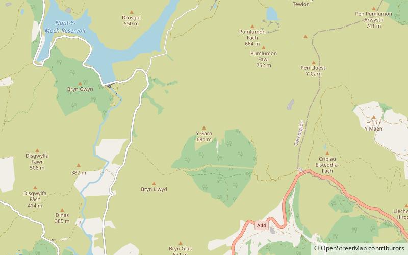
Y Garn is a subsidiary summit of Pen Pumlumon Fawr and the fourth highest peak on the Plynlimon massif, a part of the Cambrian Mountains in the county of Ceredigion, Wales. ()
WalesUnited Kingdom
Y Garn – popular in the area (distance from the attraction)
Nearby attractions include: Plynlimon, Pen y Garn, The Silver Mountain Experience, Mynach Falls.
1.4 miNENature, Natural attraction, MountainPlynlimon
36 min walk • Pumlumon is the highest point of the Cambrian Mountains in Wales, and the highest point in Mid Wales. It is a massif that dominates the surrounding countryside and is the highest point of Ceredigion.
5.2 miSNature, Natural attraction, MountainPen y Garn
133 min walk • Pen y Garn is a mountain in the Cambrian Mountains, Mid Wales standing at 611 metres above sea level. Pen y Garn tops a 500–600 m high plateau, which includes the controversial Cefn Croes wind farm.
3.8 miSW 5.5 miSNature, Natural attraction, WaterfallMynach Falls, Devil's Bridge
139 min walk • Mynach Falls is a waterfall near Aberystwyth in the county of Ceredigion, Wales. It occurs where the River Mynach drops 90 metres in 5 steps down a steep and narrow ravine before it meets the River Rheidol.
5.1 miNENature, Natural attraction, ForestHafren Forest
130 min walk • Hafren Forest lies north-west of Llanidloes, an ancient market town in Mid Wales.
5.3 miSWNature, Natural attraction, CanyonCoed Rheidol National Nature Reserve, Devil's Bridge
134 min walk • Coed Rheidol National Nature Reserve forms part of the long ribbon of woodland adjoining the Afon Mynach and Afon Rheidol around the lower slopes of hills near Devil's Bridge, Ceredigion.
1.9 miNWNature, Natural attraction, LakeNant-y-moch Reservoir
50 min walk • Nant-y-moch Reservoir Welsh pronunciation is situated in the Cambrian Mountains in northern Ceredigion, Wales, near Pumlumon. The reservoir which flooded a part of the valley of the River Rheidol and its headwaters derives its name from a stream, the Nant-y-moch, which formerly flowed into the River Rheidol at this spot.
5.6 miSWZooThe Magic of Life Butterfly House, Ponterwyd
143 min walk • The Magic of Life Butterfly House is an all-weather butterfly zoo visitor attraction near Aberystwyth, Ceredigion in Wales. It was opened in July 2002 by rain forest conservationist, the Earl of Cranbrook.
4.8 miWNature, Natural attraction, ValleyCwmsymlog
123 min walk • Cwmsymlog is a short valley, sheltering a hamlet of the same name, in Ceredigion, in the west of Wales. Once an important mining area, but the mining slowly declined and finally came to an end in 1901.
5.5 miNENature, Natural attraction, MountainBanc Bugeilyn
141 min walk • Banc Bugeilyn is a hill found in Plynlimon between Aberystwyth and Welshpool in the United Kingdom; grid reference SN826925. The summit is class as a Dewey. The height of the summit from sea level is 551 m.
5.8 miNNature, Natural attraction, WaterfallPistyll y Llyn, Machynlleth
148 min walk • Pistyll y Llyn is one of the tallest waterfalls in Wales and the United Kingdom. It is a horsetail style set of falls which are located in the Cambrian Mountains about 2+1⁄2 miles from Glaspwll in Powys, Wales.