Glamaig, Sligachan
#5 among attractions in Sligachan

Facts and practical information
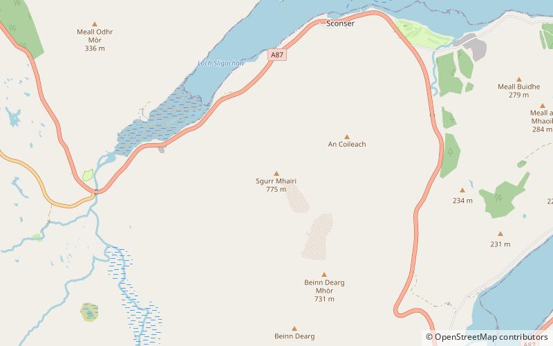
Glamaig is the northernmost of the Red Hills on the Isle of Skye in Scotland. It lies immediately east of Sligachan. It is one of only two Corbetts on Skye. ()
Sligachan United Kingdom
Sligachan plan & book
Unleash the traveler in you — discover the cheapest flight deals, find the perfect hotel or hostel nearby, and search for the best car rental prices. Travel at your own pace to discover new places and enjoy your journey.
Glamaig – popular in the area (distance from the attraction)
Nearby attractions include: Sgùrr Dearg, Sgùrr nan Gillean, Am Basteir, Blà Bheinn.
 Nature, Natural attraction, Volcano
Sgùrr Dearg, Glenbrittle
173 min walk • Sgùrr Dearg is a mountain in the Cuillin on the Isle of Skye, Scotland. It is topped by the Inaccessible Pinnacle, a fin of rock measuring 50 metres along its longest edge. The top of the Inaccessible Pinnacle, which at 985.8 m is the highest point of Sgùrr Dearg and the only Munro with a peak that can only be reached by rock climbing.
 Mountain with hiking and climbing routes
Sgùrr nan Gillean, Sligachan
100 min walk • Sgùrr nan Gillean is a mountain in the northern section of the Cuillin range on the Isle of Skye in Scotland. With a height of 966.1 metres, it is one of eleven Munros in the Cuillin ridge.
 Natural attraction, Mountain
Am Basteir, Sligachan
107 min walk • Am Basteir is a mountain in the northern Cuillin range on the Isle of Skye in Scotland. It is 934 metres high and classed as a Munro. It forms a narrow blade of rock, which bears comparison with the Inaccessible Pinnacle.
 Nature, Natural attraction, Mountain
Blà Bheinn, Isle of Skye
134 min walk • Blà Bheinn, is a mountain on the Isle of Skye in Scotland. It is usually regarded as an outlier to the Black Cuillin. It is mainly composed of gabbro, a rock with excellent grip for mountaineers and scramblers. The name Blà Bheinn is thought to mean "blue mountain", from a combination of Norse and Gaelic.
 Mountain
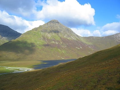
Beinn Dearg Mhor, Sligachan
27 min walk • Beinn Dearg Mhor, is a mountain in the Red Cuillin mountains of the Isle of Skye. It is located between Loch Ainort and the settlement of Sligachan.
 Nature, Natural attraction, Mountain
Bruach na Frìthe, Isle of Skye
113 min walk • Bruach na Frìthe is one of the principal summits on the Black Cuillin ridge, on the Isle of Skye, Scotland. Like the rest of the range it is composed of gabbro, a rock with excellent grip for mountaineering.
 Nature, Natural attraction, Mountain
Sgùrr na Banachdaich, Glenbrittle
167 min walk • Sgùrr na Banachdaich is most difficult of the main Black Cuillin peaks to ascend. The simplest route ascends via Coire nan Eich from Glen Brittle. Knowledge of ropes are likely to be required until the summit is reached.
 Mountain
Belig, Sligachan
106 min walk • Belig, is a mountain in the Cuillin mountains of the Isle of Skye. It is located in the centre of the island, northeast of the main Black Cuillin range. A fine and sharp peak, Belig's summit is the culmination of three ridges. It is often climbed in conjunction with its neighbour Garbh-bheinn. The nearest village is Dunan to the east.
 Nature, Natural attraction, Mountain
Sgùrr a' Ghreadaidh, Glenbrittle
154 min walk • Sgùrr a' Ghreadaidh is the highest summit on the northern half of the Black Cuillin ridge on the Isle of Skye in Scotland. Like the rest of the range it is composed of gabbro, a rock that provides good grip for mountaineering.
 Nature, Natural attraction, Mountain
Sgùrr a' Mhadaidh, Glenbrittle
147 min walk • Sgùrr a' Mhadaidh is a Munro summit on the Black Cuillin ridge on the Isle of Skye, Scotland. Like the rest of the range it is composed of gabbro, a rock with excellent grip for mountaineering.
 Nature, Natural attraction, Mountain
Marsco, Isle of Skye
77 min walk • Marsco is a peak in the Red Hills on the Isle of Skye in Scotland. It lies on the east of Glen Sligachan, and may be climbed from the right-of-way through the glen from Sligachan to Loch Coruisk.


