Finnich Glen
#1756 among destinations in the United Kingdom

Facts and practical information
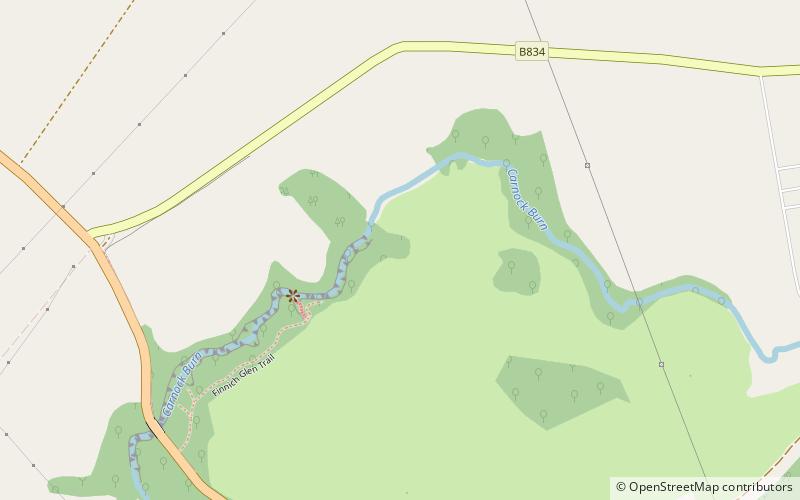
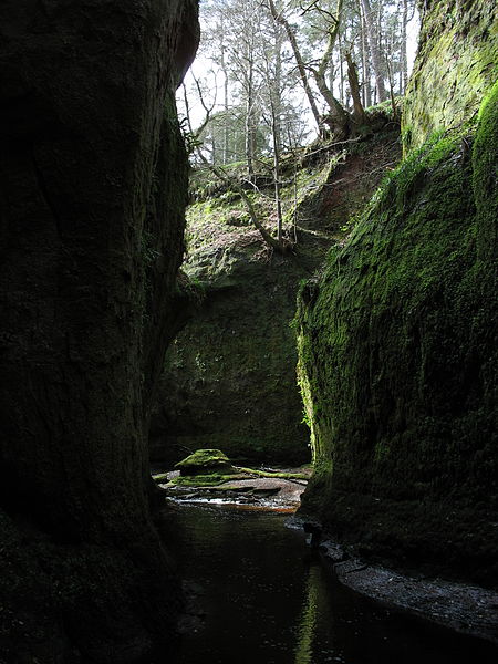
Finnich Glen in Stirlingshire, is a short, steep glen up to 70 ft deep which runs east from Finnich Bridge on the A809. It was carved from the red sandstone by the Carnock Burn. ()
ScotlandUnited Kingdom
Finnich Glen plan & book
Unleash the traveler in you — discover the cheapest flight deals, find the perfect hotel or hostel nearby, and search for the best car rental prices. Travel at your own pace to discover new places and enjoy your journey.
Finnich Glen – popular in the area (distance from the attraction)
Nearby attractions include: Rob Roy Way, Dumgoyne, Loch Lomond National Nature Reserve, Buchanan Castle.
 Hiking, Hiking trail
Rob Roy Way, Drymen
69 min walk • The Rob Roy Way is a Scottish long distance footpath that runs from Drymen in Stirling to Pitlochry in Perth and Kinross. The path was created in 2002, and takes its name from Rob Roy MacGregor, a Scottish folk hero and outlaw of the early 18th century.
 Volcano, Nature, Natural attraction
Dumgoyne, Glasgow
78 min walk • Dumgoyne is a hill prominent on the edge of the Campsie Fells and is a well-known landmark visible from Glasgow. It is a volcanic plug and is 427 m high.
 Area
AreaLoch Lomond National Nature Reserve, Balmaha
161 min walk • Loch Lomond National Nature Reserve encompasses 430 hectares of land at the southeastern part of Loch Lomond in the council areas of Stirling and West Dunbartonshire, in Scotland.
 Golf, Forts and castles
Buchanan Castle, Drymen
81 min walk • Buchanan Castle is a ruined country house in Stirlingshire, Scotland, located 1 mile west of the village of Drymen. The house was commissioned by The 4th Duke of Montrose and built in 1852-1858 as a home for the Montrose family, serving as such until 1925.
 Nature, Natural attraction, Hill
Campsie Fells
117 min walk • The Campsie Fells are a range of hills in central Scotland, stretching east to west from Denny Muir to Dumgoyne in Stirlingshire and overlooking Strathkelvin to the south. The southern extent of the range falls within East Dunbartonshire.
 Park
ParkMugdock Country Park, Glasgow
152 min walk • Mugdock Country Park is a country park and historical site located partly in East Dunbartonshire and partly in Stirling, in the former county of Stirlingshire, Scotland.
 Neighbourhood
Conic Hill, Loch Lomond and The Trossachs National Park
156 min walk • Conic Hill is a prominent hill in Stirling, Scotland.
 Nature, Natural attraction, Hill
Kilpatrick Hills
127 min walk • The Kilpatrick Hills are a range of hills in central Scotland, stretching from Dumbarton in the west to Strathblane in the east. Strathblane divides the Kilpatricks from the Campsie Fells to the east, while to the north is part of the Loch Lomond and the Trossachs National Park.
 Forts and castles
Ballikinrain
111 min walk • Ballikinrain is an independent residential school in Stirling, central Scotland. It is run by CrossReach, a social care outreach arm of the Church of Scotland.
 Wooded island with trails and campsites
Inchcailloch, Balmaha
163 min walk • Inchcailloch is an islet on Loch Lomond in Scotland. It is 85 metres at its highest point. It is also known to some as Inchebroida. The name Inchcailloch means "Isle of the old woman" or "Isle of the Cowled Woman" in the Scottish Gaelic language.
 Ruins
RuinsBuchanan Auld House, Loch Lomond and The Trossachs National Park
88 min walk • Buchanan Auld House is a ruined house in Stirlingshire, Scotland, located 1.5 miles west of the village of Drymen. Historic seat of the Clan Buchanan, the house was the property of the Chiefs of Clan Buchanan who controlled the surrounding lands from at least 1231 until 1682.


