Old Haydon Bridge
#2473 among destinations in the United Kingdom
![Old Haydon Bridge location map](https://tzmedia.b-cdn.net/media/images/static-maps/gb/54_973_-2_24626.jpg)
Facts and practical information
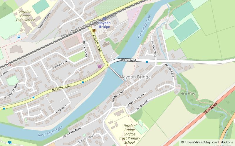
Old Haydon Bridge is a footbridge across the River South Tyne providing access between the Northern and Southern sides of the village of Haydon Bridge, Northumberland, England. ()
Old Haydon Bridge plan & book
Unleash the traveler in you — discover the cheapest flight deals, find the perfect hotel or hostel nearby, and search for the best car rental prices. Travel at your own pace to discover new places and enjoy your journey.
Old Haydon Bridge – popular in the area (distance from the attraction)
Nearby attractions include: Allen Banks & Staward Gorge, Staward Peel, Briarwood Banks, Milecastle 33.
2.9 miWNature, Natural attraction, Protected areaAllen Banks & Staward Gorge
74 min walk • Nestled in the heart of Northumberland, Allen Banks & Staward Gorge offers visitors a spectacular immersion into one of the United Kingdom's most enchanting ancient woodlands. This protected area, managed by the National Trust, is a haven for nature enthusiasts...
3.5 miSWForts and castlesStaward Peel, North Pennines
89 min walk • Staward Peel, or Staward Pele, is a peel tower located in the National Trust property of Allen Banks & Staward Gorge in Northumberland, England.
3.5 miSWNature, Natural attraction, ForestBriarwood Banks
89 min walk • Briarwood Banks is the name given to a woodland Site of Special Scientific Interest in north Northumberland, North East England. Composed mainly of elm, oak and ash, the site is semi-natural and now recovering from the removal of planted conifers.
4.1 miNAreaMilecastle 33, Hadrian's Wall
105 min walk • Milecastle 33 was a milecastle of the Roman Hadrian's Wall, one of a series of small fortlets built at intervals of approximately one Roman mile along the length of the UNESCO World Heritage Site in northern England.
4.3 miNWHistorical place, History museum, MuseumHousesteads Roman Fort, Haltwhistle
111 min walk • Housesteads Roman Fort is the remains of an auxiliary fort on Hadrian's Wall, at Housesteads, Northumberland, England, south of Broomlee Lough.
4.3 miNWMuseum, AreaHousesteads Roman Fort, Hadrian's Wall
111 min walk • Housesteads Roman Fort is the remains of an auxiliary fort on Hadrian's Wall, at Housesteads, Northumberland, England, south of Broomlee Lough.
2.7 miNWAreaStanegate, Hadrian's Wall
68 min walk • The Stanegate was an important Roman road built in what is now northern England. It linked many forts including two that guarded important river crossings: Corstopitum on the River Tyne in the east, and situated on Dere Street, and Luguvalium on the River Eden in the west.
4.4 miNWAreaMilecastle 35, Hadrian's Wall
112 min walk • Milecastle 35 is one of the milecastles on Hadrian's Wall. The remains still exist as exposed masonry.
4.3 miNAreaMilecastle 31, Hadrian's Wall
110 min walk • Milecastle 31 was a milecastle of the Roman Hadrian's Wall. Its remains exist as a turf covered platform beside the B6318 Military Road, just to the east of Carrawburgh fort.
4.2 miNWAreaMilecastle 34, Hadrian's Wall
108 min walk • Milecastle 34 was a milecastle of the Roman Hadrian's Wall. There are no visible remains, but the site is within a small, tree-filled, walled enclosure located around 0.5 kilometres east of Sewingshields farm.
4.4 miEBridgeWarden Railway Bridge
113 min walk • Warden Railway Bridge is a railway bridge carrying the Tyne Valley line between Newcastle upon Tyne and Carlisle across the River South Tyne near Warden, Northumberland.