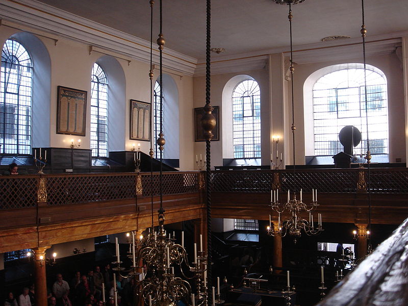
Bevis Marks Synagogue, London

Gallery (4)
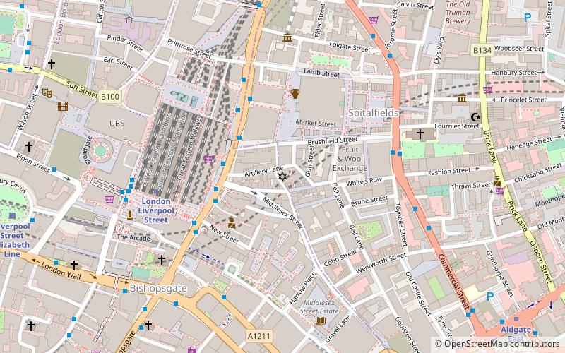
Map

Map
Gallery
Facts and practical information
Bevis Marks Synagogue, officially Qahal Kadosh Sha'ar ha-Shamayim, is the oldest synagogue in the United Kingdom in continuous use. It is located off Bevis Marks, Aldgate, in the City of London. ()
Getting there by public transportation
Public transportation stops near this location
- Metro
- Bus
- Light rail
- Train
- Ferry
 Metro
Metro
- Calculate routeAldgate 4 min walk
- Calculate routeLiverpool Street 7 min walk
- Calculate routeTower Hill 9 min walk
- Calculate routeAldgate Bus Station 5 min walk
- Calculate routeWormwood Street 5 min walk
- Calculate routeMinories 5 min walk
- Calculate routeLondon Fenchurch Street 6 min walk
- Calculate routeBank 12 min walk
- Calculate routeLondon Cannon Street 15 min walk
- Calculate routeShoreditch High Street 17 min walk
- Calculate routeTower Gateway Platform 1 9 min walk
- Calculate routeBank Platform 9 11 min walk
- Calculate routeTower Millennium Pier 13 min walk
- Calculate routeLondon Bridge City Pier 15 min walk
- Calculate routeSaint Katharine's Pier 17 min walk
- Calculate routeBankside Pier 23 min walk
Maps Tube
Tube
TubeDay trips
Bevis Marks Synagogue – popular in the area (distance from the attraction)
Nearby attractions include: Leadenhall Market, 30 St Mary Axe, Baltic Exchange, Petticoat Lane Market.


Frequently Asked Questions (FAQ)
When is Bevis Marks Synagogue open?
Bevis Marks Synagogue is open:
- Monday 10:30 am - 2 pm
- Tuesday 10:30 am - 1 pm
- Wednesday 10:30 am - 2 pm
- Thursday 10:30 am - 2 pm
- Friday 10:30 am - 1 pm
- Saturday closed
- Sunday 10:30 am - 12:30 pm
Which popular attractions are close to Bevis Marks Synagogue?
Nearby attractions include 30 St Mary Axe, London (2 min walk), Mitre Square, London (2 min walk), Baltic Exchange, London (2 min walk), St Katharine Cree, London (2 min walk).
How to get to Bevis Marks Synagogue by public transport?
The nearest stations to Bevis Marks Synagogue:
Metro
Bus
Train
Light rail
Ferry
Metro
- Aldgate • Lines: Circle, Metropolitan (4 min walk)
- Liverpool Street • Lines: Central, Circle, Hammersmith & City, Metropolitan (7 min walk)
Bus
- Aldgate Bus Station • Lines: 242, 254, N253 (5 min walk)
- Wormwood Street • Lines: 133, 26, 388, 8, N133, N242, N26, N551, N8 (5 min walk)
Train
- London Fenchurch Street (6 min walk)
- Bank (12 min walk)
Light rail
- Tower Gateway Platform 1 • Lines: Tg-B (9 min walk)
- Bank Platform 9 • Lines: B-L, B-Wa (11 min walk)
Ferry
- Tower Millennium Pier • Lines: Rb1, Rb1X, Rb2, Red Tour (13 min walk)
- London Bridge City Pier • Lines: Rb1, Rb1X, Rb2, Rb6 (15 min walk)