Dusk Till Dawn, Nottingham
Map
Facts and practical information
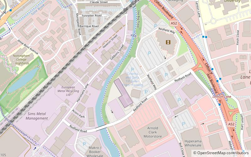
Dusk Till Dawn Poker Club is a cardroom in Nottingham, located on the Boulevard Retail Park on the edge of the city. The club opened in 2007 and is owned by Rob Yong. ()
Coordinates: 52°56'7"N, 1°10'44"W
Getting there by public transportation
Public transportation stops near this location
- Bus
- Tram
 Bus
Bus
- Calculate routeKings Meadow Campus 7 min walk
- Calculate routeFinch Close 7 min walk
- Calculate routeShowcase Cinema 7 min walk
- Calculate routeLace Street 10 min walk
- Calculate routeUniversity of Nottingham 11 min walk
- Calculate routeQueens Medical Centre 14 min walk
- Calculate routeGregory Street 16 min walk
- Calculate routeNg2 19 min walk
Day trips


Frequently Asked Questions (FAQ)
Which popular attractions are close to Dusk Till Dawn?
Nearby attractions include Priory Church of St Anthony, Nottingham (16 min walk), Highfields Park, Nottingham (17 min walk), Nottingham New Theatre, Nottingham (20 min walk), Albert Ball Memorial Homes, Nottingham (21 min walk).
How to get to Dusk Till Dawn by public transport?
The nearest stations to Dusk Till Dawn:
Bus
Tram
Bus
- Kings Meadow Campus • Lines: W1 (7 min walk)
- Finch Close • Lines: W1 (7 min walk)
Tram
- University of Nottingham • Lines: 1 (11 min walk)
- Queens Medical Centre • Lines: 1 (14 min walk)