Nicholstown, Southampton
Map
Facts and practical information
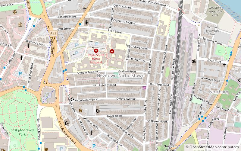
Nicholstown-Newtown is a small area to the north-east of Southampton's city centre. To the north is Bevois Valley, to the east Northam and to the west and south is St Mary's. In the north of Newtown is the Mount Pleasant area, which spills over into the north of Northam. Black signs saying "Welcome to Nicholstown-Newtown" demarcate the district on the roads running east from St. Mary's Rd – hence the district is bordered on the west by St. Mary's Road, the south by Six Dials road, and the east by the railway lines. ()
Coordinates: 50°54'41"N, 1°23'45"W
Address
Southampton Test (Bevois)Southampton
ContactAdd
Social media
Add
Getting there by public transportation
Public transportation stops near this location
- Bus
- Train
 Bus
Bus
- Calculate routeLaw Courts 9 min walk
- Calculate routeGiddy Bridge 10 min walk
- Calculate routeCenotaph 11 min walk
- Calculate routeSt Denys 21 min walk
- Calculate routeSouthampton Central 22 min walk
- Calculate routeBitterne 25 min walk
- Calculate routeWoolston 31 min walk
Day trips


Frequently Asked Questions (FAQ)
Which popular attractions are close to Nicholstown?
Nearby attractions include Franciscan Friary, Southampton (10 min walk), Titanic Engineers' Memorial, Southampton (10 min walk), St. Edmund Church, Southampton (11 min walk), Rockstone Place Park, Southampton (11 min walk).
How to get to Nicholstown by public transport?
The nearest stations to Nicholstown:
Bus
Train
Bus
- Law Courts • Lines: U1A, U2, U2B, U2C (9 min walk)
- Giddy Bridge • Lines: U1A, U2, U2B, U2C (10 min walk)
Train
- St Denys (21 min walk)
- Southampton Central (22 min walk)