Fosbury Camp
#3054 among destinations in the United Kingdom

Facts and practical information
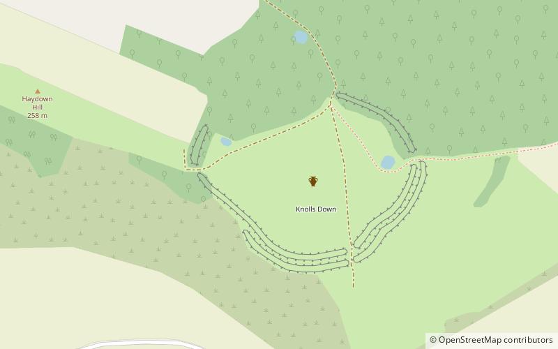
Fosbury Camp, is the site of an Iron Age bivallate hillfort located in Wiltshire. The site is oval in shape, and approximately 26 acres in area ()
EnglandUnited Kingdom
Fosbury Camp plan & book
Unleash the traveler in you — discover the cheapest flight deals, find the perfect hotel or hostel nearby, and search for the best car rental prices. Travel at your own pace to discover new places and enjoy your journey.
Fosbury Camp – popular in the area (distance from the attraction)
Nearby attractions include: Wayfarer's Walk, Test Way, Crofton Beam Engines, Wilton Windmill.
 Hiking, Hiking trail
Wayfarer's Walk
120 min walk • Nestled in the picturesque landscape of the United Kingdom, the Wayfarer's Walk is a haven for hiking enthusiasts and nature lovers alike. This enchanting hiking trail stretches over 70 miles, offering a magnificent journey through the rolling hills and verdant...
 Hiking, Hiking trail
Test Way
121 min walk • The Test Way is a 44-mile long-distance footpath in England from Walbury Hill in West Berkshire to Eling in Hampshire, which follows much of the course of the River Test. The northern end of the footpath starts in the car park on Walbury Hill.
 Historical place, History museum, Museum
Crofton Beam Engines, Marlborough
129 min walk • Crofton Pumping Station, near the village of Great Bedwyn in Wiltshire, England, supplies the summit pound of the Kennet and Avon Canal with water. The steam-powered pumping station is preserved and operates on selected weekends.
 Windmill
Wilton Windmill
107 min walk • The Wilton Windmill is a five-floor brick tower mill located on a chalk ridge between the villages of Wilton and Great Bedwyn in the southern English county of Wiltshire.
 Forts and castles
Walbury Hill, Hungerford
119 min walk • Walbury Hill is a summit of the North Wessex Downs in Berkshire, England. At 297 metres above sea level, it is the highest natural point in South East England. Walbury Hill is the starting point for both the Test Way and the Wayfarer's Walk footpaths.
 Nature, Natural attraction, Hill
Pilot Hill
139 min walk • Pilot Hill is the highest summit in Hampshire, England, with a maximum elevation of 286 m. Around 2 miles to the northwest is Walbury Hill, the county top of Berkshire, which is 297 m high.
 Canal
CanalBruce Tunnel, Marlborough
170 min walk • The Bruce Tunnel is on the summit pound of the Kennet and Avon Canal between Wootton Top Lock and Crofton Locks in Wiltshire, England. The tunnel is 502 yards long.
 Forts and castles, Historical place, Ruins
Ludgershall Castle
121 min walk • Ludgershall Castle is a ruined 12th-century fortified royal residence at Ludgershall in Wiltshire, England. Three large walls still remain of the castle, which was turned into a hunting lodge by Henry III but fell into disuse by the 15th century.
 Nature, Natural attraction, Lake
Wilton Water
125 min walk • Wilton Water is a small reservoir, southwest of the village of Great Bedwyn in the English county of Wiltshire, which supplies the summit pound of the Kennet and Avon Canal with water.
 Canal
CanalCrofton Locks
136 min walk • Crofton Locks are a flight of locks on the Kennet and Avon Canal, near the village of Great Bedwyn, Wiltshire, England. The nine locks achieve a total rise/fall of 61 ft 0 in and were built under the supervision of engineer John Rennie. West of the top lock is the summit of the canal at 450 ft above sea level.
 Canal
CanalBedwyn Church Lock
137 min walk • Bedwyn Church Lock is on the Kennet and Avon Canal at Great Bedwyn, Wiltshire, England. The lock has a rise/fall of 7 ft 11 in. It is a Grade II listed building.


