St Thomas of Canterbury, London
Map

Gallery

Facts and practical information
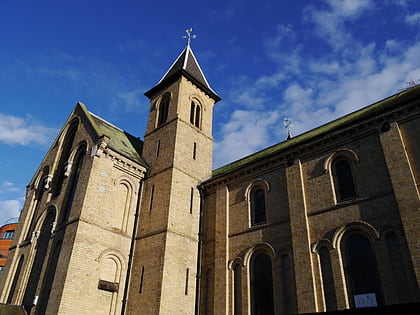
St Thomas of Canterbury Church, also known as St Thomas's, Rylston Road, is a Roman Catholic parish church in Fulham, central London. Designed in the Gothic Revival style by Augustus Pugin in 1847, the building is Grade II* listed with Historic England. It stands at 60 Rylston Road, Fulham, next to Pugin's Grade II listed presbytery and churchyard and St Thomas's primary school, also largely by Pugin, close to the junction with Lillie Road in the Borough of Hammersmith and Fulham. ()
Coordinates: 51°28'54"N, 0°12'22"W
Address
60 Rylston RoadHammersmith and Fulham (Fulham Broadway)London
ContactAdd
Social media
Add
Day trips
St Thomas of Canterbury – popular in the area (distance from the attraction)
Nearby attractions include: Queen's Club, Brompton Cemetery, Craven Cottage, Bishops Park.
Frequently Asked Questions (FAQ)
Which popular attractions are close to St Thomas of Canterbury?
Nearby attractions include Fulham Cemetery, London (12 min walk), Queen's Club, London (13 min walk), Fulham Town Hall, London (13 min walk), Battersea Railway Bridge, London (15 min walk).
How to get to St Thomas of Canterbury by public transport?
The nearest stations to St Thomas of Canterbury:
Bus
Metro
Ferry
Train
Bus
- Sherbrooke Road • Lines: 211, 295, N11 (2 min walk)
- Shorrolds Road • Lines: 211, 295, N11 (4 min walk)
Metro
- Parsons Green • Lines: District (13 min walk)
- Fulham Broadway • Lines: District (13 min walk)
Ferry
- Putney Pier • Lines: Rb6 (28 min walk)
- Chelsea Harbour Pier • Lines: Rb6 (32 min walk)
Train
- Imperial Wharf (28 min walk)

 Tube
Tube


