Fremont Pass, San Isabel National Forest
#41 among attractions in San Isabel National Forest
![Fremont Pass location map](https://tzmedia.b-cdn.net/media/images/static-maps/us/39_3664_-106_187.jpg)
Facts and practical information
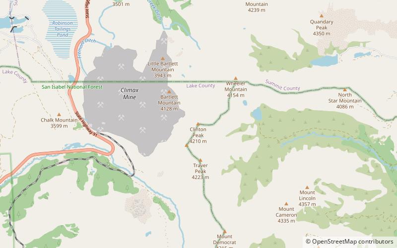
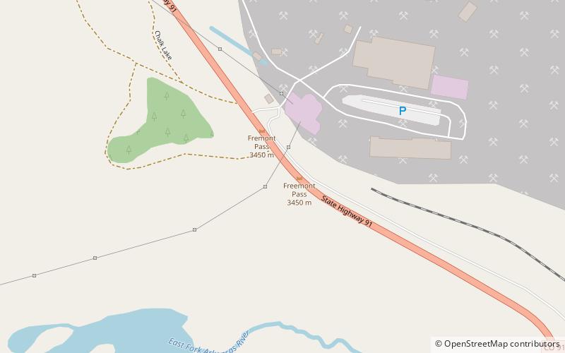
Fremont Pass is a 11,318-foot mountain pass in central Colorado, in the Rocky Mountains of the western United States. ()
San Isabel National Forest United States
Fremont Pass – popular in the area (distance from the attraction)
Nearby attractions include: Quandary Peak, Mount Democrat, Mount Lincoln, Mount Bross.
4.8 miNENature, Natural attraction, Outdoor activitiesQuandary Peak, Breckenridge
123 min walk • Quandary Peak is the highest summit of the Tenmile Range in the Rocky Mountains of North America and is the most commonly climbed fourteener in Colorado. It has nearly the same elevation as Castle Peak and Mount Evans.
3.1 miSENature, Natural attraction, MountainMount Democrat, Pike National Forest
80 min walk • Mount Democrat is a high mountain summit in the Mosquito Range of the Rocky Mountains of North America. The 14,155-foot fourteener is located 5.4 miles northwest of the Town of Alma, Colorado, United States, on the Continental Divide separating San Isabel National Forest and Lake County from Pike National Forest and Park County.
4.2 miENature, Natural attraction, View pointMount Lincoln, Alma
107 min walk • Mount Lincoln is the eighth-highest summit of the Rocky Mountains of North America and the U.S. state of Colorado. The prominent 14,293-foot fourteener is the highest summit of the Mosquito Range and the eleventh-highest summit in the contiguous United States.
4.7 miSENature, Natural attraction, View pointMount Bross, Alma
121 min walk • Mount Bross is a high mountain summit in the Mosquito Range of the Rocky Mountains of North America. The 14,178-foot fourteener is located in Pike National Forest, 4.1 miles northwest by north of the Town of Alma in Park County, Colorado, United States.
6.9 miNENatural attraction, Park, MountainPeak 10, Breckenridge
178 min walk • Peak 10, elevation 13,640 ft, is a summit in the Tenmile Range of central Colorado. The peak is southwest of Breckenridge in the Arapaho National Forest. The lowest part of Peak 10 is serviced by Breckenridge Ski Resort's Falcon SuperChair.
3.9 miSENature, Natural attraction, MountainMount Buckskin, Pike National Forest
101 min walk • Mount Buckskin is a high mountain summit in the Mosquito Range of the Rocky Mountains of North America. The 13,872-foot thirteener is located in Pike National Forest, 4.9 miles west-northwest of the Town of Alma in Park County, Colorado, United States.
2 miENature, Natural attraction, MountainClinton Peak, San Isabel National Forest
52 min walk • Clinton Peak is a high mountain summit in the Mosquito Range of the Rocky Mountains of North America. The 13,864-foot thirteener is located 2.1 miles east of Fremont Pass, Colorado, United States, on the Continental Divide separating San Isabel National Forest and Lake County from Pike National Forest and Park County.
4.2 miENature, Natural attraction, Natural featureMosquito Range, Pike National Forest
107 min walk • The Mosquito Range is a high mountain range in the Rocky Mountains of central Colorado in the United States. The peaks of the range form a ridge running north–south for roughly 40 mi from southern Summit County on the north end, then along the boundary between Lake and Park Counties.