Los Angeles Country Club, Los Angeles
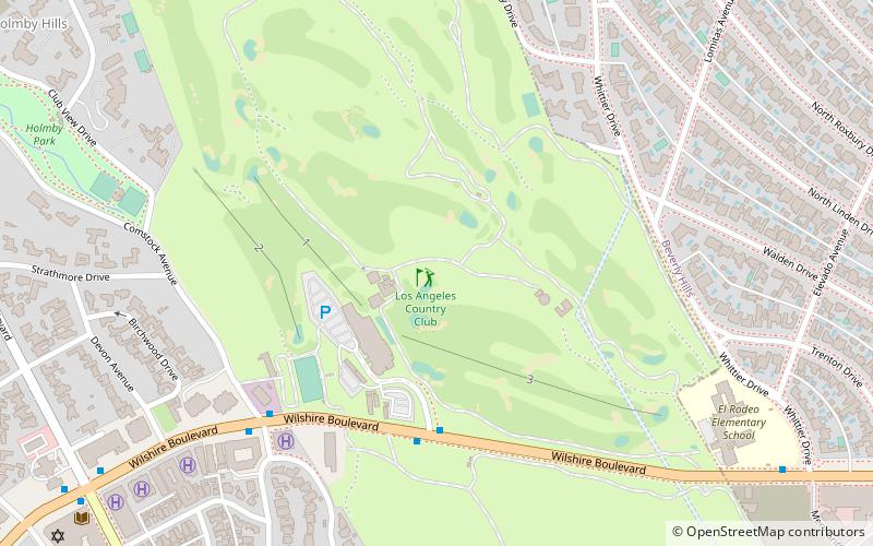
Map
Facts and practical information
The Los Angeles Country Club is a golf and country club in the Western United States, located in Los Angeles, California. ()
Established: 1897 (129 years ago)Coordinates: 34°4'13"N, 118°25'19"W
Address
10101 Wilshire BlvdWest Los Angeles (Westwood)Los Angeles 90024-4703
Contact
+1 310-276-6104
Social media
Add
Getting there by public transportation
Public transportation stops near this location
- Bus
 Bus
Bus
- Calculate routeSunset & Whittier 13 min walk
- Calculate routeSanta Monica & Century Park East 16 min walk
Maps Metro & Regional Rail
Metro & Regional RailDay trips


Frequently Asked Questions (FAQ)
Which popular attractions are close to Los Angeles Country Club?
Nearby attractions include Holmby Park, Los Angeles (13 min walk), Sinai Temple, Los Angeles (13 min walk), St. Timothy Catholic Church, Los Angeles (15 min walk), Playboy Mansion, Los Angeles (16 min walk).
How to get to Los Angeles Country Club by public transport?
The nearest stations to Los Angeles Country Club:
Bus
Bus
- Sunset & Whittier • Lines: 2 (13 min walk)
- Santa Monica & Century Park East • Lines: 4 (16 min walk)